IMAGES TAKEN NEAR TO
Clanna Lane, LYDNEY, GL15 6BD
Introduction
This page details the photographs taken nearby to Clanna Lane, GL15 6BD by members of the Geograph project.
The Geograph project started in 2005 with the aim of publishing, organising and preserving representative images for every square kilometre of Great Britain, Ireland and the Isle of Man.

There are currently over 7.5m images from over14,400 individuals and you can help contribute to the project by visiting https://www.geograph.org.uk
Image Map
Images are licensed for reuse under creativecommons.org/licenses/by-sa/2.0
Notes
- Clicking on the map will re-center to the selected point.
- The higher the marker number, the further away the image location is from the centre of the postcode.
Image Listing (80 Images Found)
Images are licensed for reuse under creativecommons.org/licenses/by-sa/2.0
Image
Details
Distance
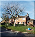
1
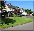
Clanna Lane houses, Alvington
The name sign on the left shows CLANNA LANE.
Image: © Jaggery
Taken: 18 Sep 2016
0.00 miles
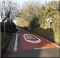
2
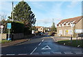
Clanna Lane, Alvington
Ahead, the 30mph speed limit on Clanna Lane increases to the National Speed Limit.
The road on the right leads to Nuppend Farm Stud.
Image: © Jaggery
Taken: 18 Sep 2016
0.03 miles
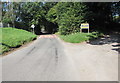
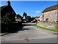
3
End of the 30mph speed limit along Clanna Road, Alvington
The National Speed Limit applies ahead. Clanna Road behind the camera narrows to Clanna Lane ahead.
Image: © Jaggery
Taken: 1 Jan 2013
0.05 miles
4
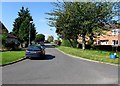
Garlands Road, Alvington
Viewed from Clanna Road.
Image: © Jaggery
Taken: 18 Sep 2016
0.07 miles
5
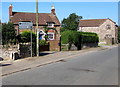
Garlands Road houses, Alvington
Viewed from the corner of Clanna Road.
Image: © Jaggery
Taken: 1 Jan 2013
0.07 miles
6
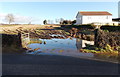
Watery entrance to a field, Alvington
Viewed across Clanna Road on January 1st 2013, after a very wet December and the wettest year on record in many parts of England.
Image: © Jaggery
Taken: 1 Jan 2013
0.08 miles
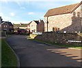
7
Malt House Close, Alvington
Cul-de-sac extending for 30 metres from the west side of Clanna Road.
Image: © Jaggery
Taken: 18 Sep 2016
0.09 miles
8
Malt House Close, Alvington
A short cul-de-sac on the west side of Clanna Road.
Image: © Jaggery
Taken: 1 Jan 2013
0.10 miles
9
Clanna Road, Alvington
Clanna Road heads away from the A48, towards Hewelsfield (2½ miles) and Brockweir (4 miles).
A sign on the left states that Clanna Road is a single track road with passing places.
Image: © Jaggery
Taken: 1 Jan 2013
0.10 miles
10
Directions and distances sign, Clanna Road, Alvington
Left for Aylburton (1¼ (miles)), right for Netherend (¾) .
Image: © Jaggery
Taken: 18 Sep 2016
0.12 miles