IMAGES TAKEN NEAR TO
Cone Valley, LYDNEY, GL15 6AD
Introduction
This page details the photographs taken nearby to Cone Valley, GL15 6AD by members of the Geograph project.
The Geograph project started in 2005 with the aim of publishing, organising and preserving representative images for every square kilometre of Great Britain, Ireland and the Isle of Man.

There are currently over 7.5m images from over14,400 individuals and you can help contribute to the project by visiting https://www.geograph.org.uk
Image Map
Images are licensed for reuse under creativecommons.org/licenses/by-sa/2.0
Notes
- Clicking on the map will re-center to the selected point.
- The higher the marker number, the further away the image location is from the centre of the postcode.
Image Listing (42 Images Found)
Images are licensed for reuse under creativecommons.org/licenses/by-sa/2.0
Image
Details
Distance
1
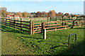
Children's play area near Woolaston Memorial Hall
The play area is between the hall http://www.geograph.org.uk/photo/3231035 and a recreation field.
Image: © Jaggery
Taken: 18 Nov 2012
0.09 miles
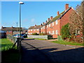
2
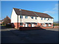
Swains Field houses, Woolaston
These houses face Woolaston Memorial Hall. http://www.geograph.org.uk/photo/3231035
Image: © Jaggery
Taken: 18 Nov 2012
0.09 miles
4
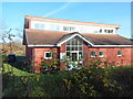
Woolaston Memorial Hall
Located at the eastern end of the residential street Swains Field. This memorial hall and community centre was officially opened on May 1st 2006. It replaced the first memorial hall, opened in July 1961.
Image: © Jaggery
Taken: 18 Nov 2012
0.11 miles
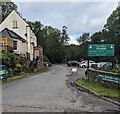
5
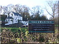
The Swan Inn, Alvington with sign
Image: © Nick Mutton 01329 000000
Taken: 2 Dec 2007
0.13 miles
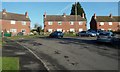
6
Netherend Crescent houses, Woolaston
Looking west from near the memorial hall. http://www.geograph.org.uk/photo/3231035
Image: © Jaggery
Taken: 18 Nov 2012
0.13 miles
7
Unsuitable road for HGVs, Netherend, Woolaston
Viewed a few tens of metres north of the Severn View Road junction. http://www.geograph.org.uk/photo/3231006
Image: © Jaggery
Taken: 18 Nov 2012
0.13 miles
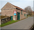
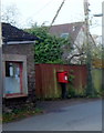
8
Netherend Post Office, Woolaston
The tiny size of the single-storey post office contrasts with the "beefy" postbox outside. http://www.geograph.org.uk/photo/3231123
Image: © Jaggery
Taken: 18 Nov 2012
0.13 miles
9
Large postbox outside tiny Netherend post office, Woolaston
There is an interesting contrast in the sizes of the postbox and post office. http://www.geograph.org.uk/photo/3231117
Image: © Jaggery
Taken: 18 Nov 2012
0.13 miles
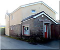
10
Swan House Tea Room, Alvington, Gloucestershire
Set back from the A48 viewed in October 2023.
The Swan Inn https://www.geograph.org.uk/photo/3231422 was here in 2012.
Image: © Jaggery
Taken: 22 Oct 2023
0.14 miles