1
Brehal Close, Lydney
Cul-de-sac viewed across Church Road. Lydney is twinned with Bréhal, a commune in Normandy, France.
Image: © Jaggery
Taken: 15 Apr 2018
0.03 miles
2
Lych Gate Mews, Lydney
From the west side of Church Road opposite St Mary's Church, Lych Gate Mews
leads to Steeple View, Vicarage Close, Chantry Close and Bishops Gate.
Image: © Jaggery
Taken: 15 Apr 2018
0.05 miles
3
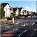
Church Road houses, Lydney
A view SE from near the Whitecross Road junction.
Image: © Jaggery
Taken: 1 Jan 2013
0.06 miles
4
Bend in Church Road, Lydney
Image: © David Martin
Taken: 6 Apr 2022
0.06 miles
5
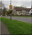
Warning sign - School, Church Road, Lydney
Facing northbound traffic on Church Road. The lights below the sign
flash when schoolchildren are likely to be crossing the road ahead.
Image: © Jaggery
Taken: 15 Apr 2018
0.06 miles
6
Steeple View, Lydney
Steeple View is a short cul-de-sac close to Church Road. This view is from the corner of Lych Gate Mews.
The steeple in question is this one. http://www.geograph.org.uk/photo/1944206
Image: © Jaggery
Taken: 26 Jun 2010
0.06 miles
7
Black signpost on the west side of Church Road, Lydney
Left for toilets and the town centre. Right for the boating lake.
Image: © Jaggery
Taken: 15 Apr 2018
0.06 miles
8
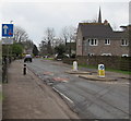
Church Road traffic calming, Lydney
Vehicles on the camera side have priority through the narrow part of Church Road alongside the sign.
The top of the spire https://www.geograph.org.uk/photo/1944206 of St Mary's Church is in the background.
Image: © Jaggery
Taken: 15 Apr 2018
0.06 miles
9
War memorial, Church Road, Lydney
Image: © nick macneill
Taken: 13 Oct 2012
0.07 miles
10
Keep Clear Zone, Church Road, Lydney
At the entrance to the Dean Academy (formerly Whitecross School) and
Freedom Leisure Lydney (formerly Whitecross Leisure Centre).
Image: © Jaggery
Taken: 15 Apr 2018
0.07 miles


