IMAGES TAKEN NEAR TO
The Millrough, Primrose Hill, LYDNEY, GL15 5TE
Introduction
This page details the photographs taken nearby to The Millrough, Primrose Hill, GL15 5TE by members of the Geograph project.
The Geograph project started in 2005 with the aim of publishing, organising and preserving representative images for every square kilometre of Great Britain, Ireland and the Isle of Man.

There are currently over 7.5m images from over14,400 individuals and you can help contribute to the project by visiting https://www.geograph.org.uk
Image Map
Images are licensed for reuse under creativecommons.org/licenses/by-sa/2.0
Notes
- Clicking on the map will re-center to the selected point.
- The higher the marker number, the further away the image location is from the centre of the postcode.
Image Listing (53 Images Found)
Images are licensed for reuse under creativecommons.org/licenses/by-sa/2.0
Image
Details
Distance
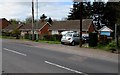
1

The Millrough, Primrose Hill, Lydney
The redbrick houses are numbers 1-8 The Millrough, a separately named and numbered part of Primrose Hill. Millrough Wood is nearby.
Image: © Jaggery
Taken: 16 Apr 2017
0.00 miles
2
Primrose Hill bungalows, Lydney
Originally, bungalow was used in English for a lightly-built house, with a veranda and one storey.
In current UK usage it is a convenient word for any one-storey dwelling.
Image: © Jaggery
Taken: 16 Apr 2017
0.01 miles
3
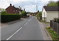
South along Primrose Hill, Lydney
Primrose Hill descends towards the town centre about 1200 metres ahead.
Image: © Jaggery
Taken: 16 Apr 2017
0.04 miles
4

Track into Millrough Wood, Lydney
From Primrose Hill, on the right here. http://www.geograph.org.uk/photo/5374538
Image: © Jaggery
Taken: 16 Apr 2017
0.04 miles
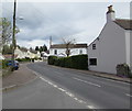
5

Primrose Hill houses, Lydney
On the west side of Primrose Hill, north of Lynwood Road.
Image: © Jaggery
Taken: 16 Apr 2017
0.04 miles
6
Primrose Hill houses, Lydney
Eight semi-detached houses which from this viewpoint look like one row of houses.
Image: © Jaggery
Taken: 16 Apr 2017
0.04 miles
7

Public footpath on the east side of Primrose Hill, Lydney
A green Public Footpath sign on the corner of Primrose Hill points along the path towards Lancaster Drive.
Image: © Jaggery
Taken: 16 Apr 2017
0.06 miles
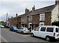
8
North along Primrose Hill, Lydney
Primrose Hill from the corner of Lynwood Road.
Image: © Jaggery
Taken: 16 Apr 2017
0.07 miles
9
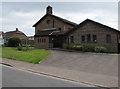
Holy Trinity Church, Primrose Hill, Lydney
Holy Trinity is part of Lydney Parish in the Church of England Diocese of Gloucester.
Image: © Jaggery
Taken: 16 Apr 2017
0.09 miles
10
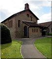
Path to Holy Trinity Church, Lydney
From Primrose Hill. Holy Trinity is part of Lydney Parish in the Church of England Diocese of Gloucester.
http://www.geograph.org.uk/photo/5352910 to another view.
Image: © Jaggery
Taken: 16 Apr 2017
0.09 miles