IMAGES TAKEN NEAR TO
Dean Court, LYDNEY, GL15 5TD
Introduction
This page details the photographs taken nearby to Dean Court, GL15 5TD by members of the Geograph project.
The Geograph project started in 2005 with the aim of publishing, organising and preserving representative images for every square kilometre of Great Britain, Ireland and the Isle of Man.

There are currently over 7.5m images from over14,400 individuals and you can help contribute to the project by visiting https://www.geograph.org.uk
Image Map
Images are licensed for reuse under creativecommons.org/licenses/by-sa/2.0
Notes
- Clicking on the map will re-center to the selected point.
- The higher the marker number, the further away the image location is from the centre of the postcode.
Image Listing (50 Images Found)
Images are licensed for reuse under creativecommons.org/licenses/by-sa/2.0
Image
Details
Distance
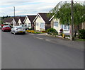
1
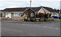
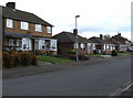
Bungalows on a suburban corner of Lydney
On the corner of Dean Court and Charnwood Court.
Originally, bungalow was used in English for a lightly-built house, with a veranda and one storey.
In current UK usage it is a convenient word for any one-storey dwelling.
Image: © Jaggery
Taken: 16 Apr 2017
0.03 miles
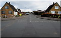
2
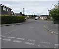
Dean Court, Lydney
From School Crescent along Dean Court towards the corner of Charnwood Court.
Image: © Jaggery
Taken: 16 Apr 2017
0.04 miles
3
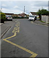
School Keep Clear zone, School Crescent, Lydney
The yellow markings define the no stopping or parking area
on the approach to Primrose Hill C of E Primary Academy and Nursery. http://www.geograph.org.uk/photo/5352935
Image: © Jaggery
Taken: 16 Apr 2017
0.06 miles
4
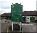
Green and yellow nameboard, Lydney
Facing the entrance to Primrose Hill C of E Primary Academy and Nursery.
Image: © Jaggery
Taken: 16 Apr 2017
0.06 miles
5
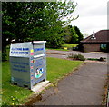
Clothing bank in the grounds of a Lydney school
Located alongside the entrance to Primrose Hill C of E Primary Academy and Nursery, the clothing bank is for donations of clean & dry clothing, paired shoes, handbags and belts. Text on the clothing bank includes Supported by BTR Ltd.
Image: © Jaggery
Taken: 16 Apr 2017
0.06 miles
6
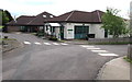
Primrose Hill C of E Primary Academy and Nursery, Lydney
Church of England Primary Academy and Nursery viewed from the southern end of School Crescent.
Image: © Jaggery
Taken: 16 Apr 2017
0.06 miles
7
School Crescent, Lydney
From Court Road along School Crescent towards Dean Court
and Primrose Hill C of E Primary Academy and Nursery. http://www.geograph.org.uk/photo/5352935
Image: © Jaggery
Taken: 16 Apr 2017
0.07 miles
8
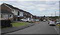
Primrose Way houses, Lydney
Bungalows between two-storey houses on the north side of Primrose Way.
Image: © Jaggery
Taken: 16 Apr 2017
0.08 miles
9
School Crescent bungalows, Lydney
Viewed from the corner of Court Road.
Originally, bungalow was used in English for a lightly-built house, with a veranda and one storey.
In current UK usage it is a convenient word for any one-storey dwelling.
Image: © Jaggery
Taken: 16 Apr 2017
0.10 miles
10
Lancaster Drive, Lydney
North along Lancaster Drive from Primrose Way.
Image: © Jaggery
Taken: 16 Apr 2017
0.10 miles