IMAGES TAKEN NEAR TO
Lynwood Road, LYDNEY, GL15 5SG
Introduction
This page details the photographs taken nearby to Lynwood Road, GL15 5SG by members of the Geograph project.
The Geograph project started in 2005 with the aim of publishing, organising and preserving representative images for every square kilometre of Great Britain, Ireland and the Isle of Man.

There are currently over 7.5m images from over14,400 individuals and you can help contribute to the project by visiting https://www.geograph.org.uk
Image Map
Images are licensed for reuse under creativecommons.org/licenses/by-sa/2.0
Notes
- Clicking on the map will re-center to the selected point.
- The higher the marker number, the further away the image location is from the centre of the postcode.
Image Listing (55 Images Found)
Images are licensed for reuse under creativecommons.org/licenses/by-sa/2.0
Image
Details
Distance
2
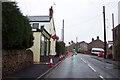
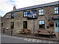
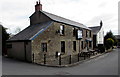
The Severn View pub, Lynwood Road, Lydney
Formerly named the Severn View Inn, the Severn View is a pub in Lynwood Road near the corner of Primrose Hill in one of the higher locations in Lydney from which there are good views of the River Severn, in this area about 2.5km (a mile and a half) wide.
Image: © Jaggery
Taken: 16 Apr 2017
0.02 miles
3
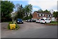
The Severn View pub car park, Lynwood Road, Lydney
On the west side of the pub. http://www.geograph.org.uk/photo/5352183 The trees are at the edge of Millrough Wood.
Image: © Jaggery
Taken: 16 Apr 2017
0.03 miles
4
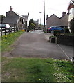
Lynwood Road, Lydney
Viewed from the corner of Primrose Hill.
Image: © Jaggery
Taken: 16 Apr 2017
0.03 miles
5
From grass to roadway, Lynwood Road, Lydney
Looking towards the Severn View pub on the left http://www.geograph.org.uk/photo/5352183 and Primrose Hill.
A track http://www.geograph.org.uk/photo/5352169 into Millrough Wood is behind the camera.
Image: © Jaggery
Taken: 16 Apr 2017
0.03 miles
6
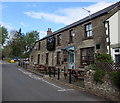
The Severn View name sign and picnic tables, Lydney
On the south side of this pub http://www.geograph.org.uk/photo/5352183 in Lynwood Road.
Image: © Jaggery
Taken: 16 Apr 2017
0.03 miles
7
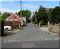
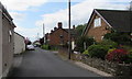
West along Lynwood Road, Lydney
This southern part of Lynwood Road extends westwards for 100 metres
from Primrose Hill, past the Severn View pub, to the edge of Millrough Wood.
Image: © Jaggery
Taken: 16 Apr 2017
0.03 miles
8
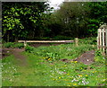
Wooden barrier across a track into Millrough Wood, Lydney
At the western end of Lynwood Road, the barrier prevents vehicular misuse of a track http://www.geograph.org.uk/photo/5352169 into Millrough Wood.
Image: © Jaggery
Taken: 16 Apr 2017
0.03 miles
9
The Severn View pub, Lynwood Road, Lydney
Formerly named the Severn View Inn, the Severn View is a pub in Lynwood Road near the corner of Primrose Hill in one of the higher locations in Lydney from which there are good views of the River Severn, in this area about 2.5km (a mile and a half) wide.
Image: © Jaggery
Taken: 16 Apr 2017
0.03 miles
10
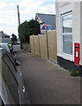
King George VI postbox in a Primrose Hill wall, Lydney
Viewed in April 2017. The Primrose Hill Cottage Store seen in a July 2009
Google Earth Street View has been demolished and replaced by a wooden fence.
Image: © Jaggery
Taken: 16 Apr 2017
0.04 miles