IMAGES TAKEN NEAR TO
Alderdale, LYDNEY, GL15 5NG
Introduction
This page details the photographs taken nearby to Alderdale, GL15 5NG by members of the Geograph project.
The Geograph project started in 2005 with the aim of publishing, organising and preserving representative images for every square kilometre of Great Britain, Ireland and the Isle of Man.

There are currently over 7.5m images from over14,400 individuals and you can help contribute to the project by visiting https://www.geograph.org.uk
Image Map
Images are licensed for reuse under creativecommons.org/licenses/by-sa/2.0
Notes
- Clicking on the map will re-center to the selected point.
- The higher the marker number, the further away the image location is from the centre of the postcode.
Image Listing (42 Images Found)
Images are licensed for reuse under creativecommons.org/licenses/by-sa/2.0
Image
Details
Distance
1
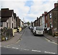
Queen Street, Lydney
The Albert Street end of a dead-end street extending for about 250 metres.
Image: © Jaggery
Taken: 16 Apr 2017
0.14 miles
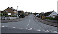
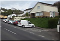
2
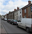
Vehicles and houses, Queen Street, Lydney
The east side of Queen Street viewed from the corner of Albert Street on Easter Sunday April 16th 2017.
Image: © Jaggery
Taken: 16 Apr 2017
0.17 miles
3

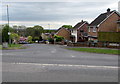
Woodland Rise, Lydney
From Albert Street, Woodland Rise ascends steeply into the Lynwood Park Estate.
Image: © Jaggery
Taken: 16 Apr 2017
0.17 miles
4
Primrose Way houses, Lydney
Bungalows between two-storey houses on the north side of Primrose Way.
Image: © Jaggery
Taken: 16 Apr 2017
0.19 miles
5
Edwardian houses, Primrose Hill, Lydney
The yearstone on the semi-detached houses shows 1907.
Image: © Jaggery
Taken: 16 Apr 2017
0.19 miles
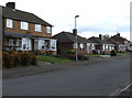
6
Kimberley Drive, Lydney
Kimberley Drive descends from Highfield Road towards Naas Lane.
Image: © Jaggery
Taken: 16 Apr 2017
0.20 miles
7
Large street name sign in suburban Lydney
On the corner here. http://www.geograph.org.uk/photo/5353727
Image: © Jaggery
Taken: 16 Apr 2017
0.20 miles
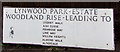
8
Large street name sign on a Lydney corner
This sign http://www.geograph.org.uk/photo/5353735 is on the corner of Woodland Rise and Albert Street.
Image: © Jaggery
Taken: 16 Apr 2017
0.20 miles
9
East along Primrose Way, Lydney
Viewed across Primrose Hill. On Primrose Way, the left turn behind the van is into Lancaster Drive. http://www.geograph.org.uk/photo/5352022
Image: © Jaggery
Taken: 16 Apr 2017
0.21 miles
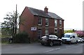
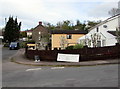
10
Roadside parking area, Albert Street, Lydney
Near the corner of Woodside Rise.
Image: © Jaggery
Taken: 16 Apr 2017
0.21 miles