
IMAGES TAKEN NEAR TO
Ash Close, LYDNEY, GL15 5NE
Introduction
This page details the photographs taken nearby to Ash Close, GL15 5NE by members of the Geograph project.
The Geograph project started in 2005 with the aim of publishing, organising and preserving representative images for every square kilometre of Great Britain, Ireland and the Isle of Man.

There are currently over 7.5m images from over14,400 individuals and you can help contribute to the project by visiting https://www.geograph.org.uk
Image Map
Images are licensed for reuse under creativecommons.org/licenses/by-sa/2.0
Notes
- Clicking on the map will re-center to the selected point.
- The higher the marker number, the further away the image location is from the centre of the postcode.
Image Listing (63 Images Found)
Images are licensed for reuse under creativecommons.org/licenses/by-sa/2.0
Image
Details
Distance
1
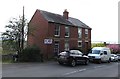
Edwardian houses, Primrose Hill, Lydney
The yearstone on the semi-detached houses shows 1907.
Image: © Jaggery
Taken: 16 Apr 2017
0.10 miles
2

WI Golden Jubilee bench, Primrose Hill, Lydney
A plaque https://www.geograph.org.uk/photo/5664735 records that the bench was presented by Primrose Hill WI (Women's Institute) in 1965, their Golden Jubilee Year.
Image: © Jaggery
Taken: 16 Apr 2017
0.12 miles
3
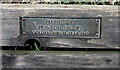
Primrose Hill Women's Institute Golden Jubilee 1965 bench plaque, Primrose Hill, Lydney
On this bench. https://www.geograph.org.uk/photo/5664727
Image: © Jaggery
Taken: 16 Apr 2017
0.12 miles
4

Fire Over England plaque, Primrose Hill Beacon, Lydney
Located on the ground below this beacon. https://www.geograph.org.uk/photo/5664767
Image: © Jaggery
Taken: 16 Apr 2017
0.12 miles
5
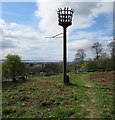
Primrose Hill Beacon, Lydney
A plaque https://www.geograph.org.uk/photo/5664775 dated 1988 records that the beacon, sponsored by BP Oil Ltd and the Wintour family, was made by Whitecross School as a project for Fire Over England to commemorate Sir William Wynter and the 400th anniversary of the Spanish Armada (1588).
Image: © Jaggery
Taken: 16 Apr 2017
0.12 miles
6

Woodland Rise, Lydney
From Albert Street, Woodland Rise ascends steeply into the Lynwood Park Estate.
Image: © Jaggery
Taken: 16 Apr 2017
0.13 miles
7

Milestone, Primrose Hill, Lydney
In front of the boundary of number 57, on the Eastern side of the road. Mileage labelled on OS maps from 1901 on.
Inscription: [Chepstow 10]
Milestone Society National ID: GL_CWCOA10
Image: © Mr Red
Taken: 24 Mar 2025
0.14 miles
8
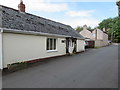
The Old Bakery, Lynwood Road, Lydney
Viewed from the corner of Primrose Hill in April 2017.
I wondered how much this bungalow has been altered externally since it was last a bakery.
Image: © Jaggery
Taken: 16 Apr 2017
0.14 miles
9
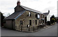
The Severn View pub, Lynwood Road, Lydney
Formerly named the Severn View Inn, the Severn View is a pub in Lynwood Road near the corner of Primrose Hill in one of the higher locations in Lydney from which there are good views of the River Severn, in this area about 2.5km (a mile and a half) wide.
Image: © Jaggery
Taken: 16 Apr 2017
0.15 miles
10
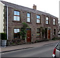
Stone semis, Primrose Hill, Lydney
The two semi-detached stone houses are on the east side of Primrose Hill.
The one on the left is named Tanith House.
Image: © Jaggery
Taken: 16 Apr 2017
0.15 miles