IMAGES TAKEN NEAR TO
Almond Walk, LYDNEY, GL15 5LP
Introduction
This page details the photographs taken nearby to Almond Walk, GL15 5LP by members of the Geograph project.
The Geograph project started in 2005 with the aim of publishing, organising and preserving representative images for every square kilometre of Great Britain, Ireland and the Isle of Man.

There are currently over 7.5m images from over14,400 individuals and you can help contribute to the project by visiting https://www.geograph.org.uk
Image Map
Images are licensed for reuse under creativecommons.org/licenses/by-sa/2.0
Notes
- Clicking on the map will re-center to the selected point.
- The higher the marker number, the further away the image location is from the centre of the postcode.
Image Listing (42 Images Found)
Images are licensed for reuse under creativecommons.org/licenses/by-sa/2.0
Image
Details
Distance
1
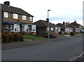
Primrose Way houses, Lydney
Bungalows between two-storey houses on the north side of Primrose Way.
Image: © Jaggery
Taken: 16 Apr 2017
0.11 miles
2
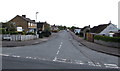
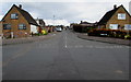
East along Primrose Way, Lydney
Viewed across Primrose Hill. On Primrose Way, the left turn behind the van is into Lancaster Drive. http://www.geograph.org.uk/photo/5352022
Image: © Jaggery
Taken: 16 Apr 2017
0.14 miles
3
Primrose Way electricity substation and bungalows, Lydney
The Western Power Distribution electricity substation, identifier 3324 PRIMROSE WAY, is located in the wooden enclosure on the right. A triangular caution label shows the presence of SF6 (sulphur hexafluoride, an insulating gas used in high voltage systems).
Image: © Jaggery
Taken: 16 Apr 2017
0.15 miles
4
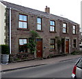
Stone semis, Primrose Hill, Lydney
The two semi-detached stone houses are on the east side of Primrose Hill.
The one on the left is named Tanith House.
Image: © Jaggery
Taken: 16 Apr 2017
0.15 miles
5
Lancaster Drive, Lydney
North along Lancaster Drive from Primrose Way.
Image: © Jaggery
Taken: 16 Apr 2017
0.15 miles
6
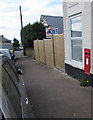
King George VI postbox in a Primrose Hill wall, Lydney
Viewed in April 2017. The Primrose Hill Cottage Store seen in a July 2009
Google Earth Street View has been demolished and replaced by a wooden fence.
Image: © Jaggery
Taken: 16 Apr 2017
0.16 miles
7
Edwardian houses, Primrose Hill, Lydney
The yearstone on the semi-detached houses shows 1907.
Image: © Jaggery
Taken: 16 Apr 2017
0.16 miles
8
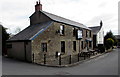
The Severn View pub, Lynwood Road, Lydney
Formerly named the Severn View Inn, the Severn View is a pub in Lynwood Road near the corner of Primrose Hill in one of the higher locations in Lydney from which there are good views of the River Severn, in this area about 2.5km (a mile and a half) wide.
Image: © Jaggery
Taken: 16 Apr 2017
0.16 miles
9
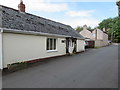
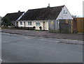
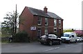
The Old Bakery, Lynwood Road, Lydney
Viewed from the corner of Primrose Hill in April 2017.
I wondered how much this bungalow has been altered externally since it was last a bakery.
Image: © Jaggery
Taken: 16 Apr 2017
0.17 miles
10
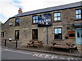
The Severn View name sign and picnic tables, Lydney
On the south side of this pub http://www.geograph.org.uk/photo/5352183 in Lynwood Road.
Image: © Jaggery
Taken: 16 Apr 2017
0.17 miles