IMAGES TAKEN NEAR TO
Queens Meadow Court, LYDNEY, GL15 5JX
Introduction
This page details the photographs taken nearby to Queens Meadow Court, GL15 5JX by members of the Geograph project.
The Geograph project started in 2005 with the aim of publishing, organising and preserving representative images for every square kilometre of Great Britain, Ireland and the Isle of Man.

There are currently over 7.5m images from over14,400 individuals and you can help contribute to the project by visiting https://www.geograph.org.uk
Image Map
Images are licensed for reuse under creativecommons.org/licenses/by-sa/2.0
Notes
- Clicking on the map will re-center to the selected point.
- The higher the marker number, the further away the image location is from the centre of the postcode.
Image Listing (566 Images Found)
Images are licensed for reuse under creativecommons.org/licenses/by-sa/2.0
Image
Details
Distance
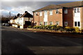
1
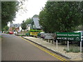
Queen's Meadow Court at Lydney
A retirement-housing development - McCarthy & Stone, of course!
Image: © M J Richardson
Taken: 24 Sep 2013
0.02 miles
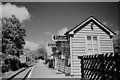
2
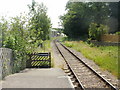
The view south from Lydney Town railway station
The line, part of the heritage Dean Forest Railway, heads away from Lydney Town station towards the southern terminus at Lydney Junction (there is a request stop in between, at St Mary's Halt.)
The buildings on the left of the track in the middle distance are retirement accommodation.http://www.geograph.org.uk/photo/1939065
Image: © Jaggery
Taken: 26 Jun 2010
0.02 miles
3
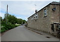
Long single-storey stone building, Swan Road, Lydney
Extending for 20 metres (about 65 feet) along Swan Road.
Image: © Jaggery
Taken: 22 May 2016
0.02 miles
4
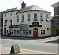
The Swan Hotel, Lydney
On the corner of Swan Road and Newerne Street, just beyond the eastern end of Hill Street. Despite its name, nowadays principally a pub with accommodation. Or, to use the slightly old-fashioned sense of the word, an inn.
Image: © Jaggery
Taken: 26 Jun 2010
0.04 miles
5
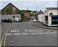
No Entry to Swan Road, Lydney
A two-way road on the camera side, Swan Road is a one-way road north of the Fairfield Road junction.
Double yellow lines on both sides indicate no parking at any time.
Image: © Jaggery
Taken: 22 May 2016
0.04 miles
6

Yard behind Lydney Fire Station
Yard and rescue tower behind Lydney Fire Station.
Image: © Philip Halling
Taken: 25 Oct 2014
0.04 miles
7
Lydney Town Station
Lydney Town is a picturesque little halt on the Dean Forest Railway. It was constructed by the DFR and opened in 2001, but it replaces a much larger and more comprehensive station which operated on or near the site until 26th October 1960, upon which date services were brought to an abrupt halt by the destruction of the nearby Severn railway bridge. There were no trains on the day I took this.
Image: © John Winder
Taken: 9 May 2015
0.05 miles
8
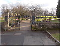
An entrance to Bathurst Park, Lydney
This entrance is from Bathurst Park Road. An inscription on a gate pillar states that the gates and fencing were presented to the people of Lydney by John H. Watts Esq. to commemorate the coronation of H.M. Queen Elizabeth II on June 2nd 1953.
Image: © Jaggery
Taken: 8 Feb 2013
0.05 miles
9
A corner of Bathurst Park
Looking to the houses in Bathurst Park Road.
Image: © David Martin
Taken: 6 Apr 2022
0.05 miles
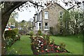
10
Fairfield Road Lydney
Houses on the north side of Fairfield Road, viewed from the corner of Regent Street looking towards Swan Road.
Image: © Jaggery
Taken: 1 Jan 2013
0.05 miles