IMAGES TAKEN NEAR TO
Hill Street, LYDNEY, GL15 5HQ
Introduction
This page details the photographs taken nearby to Hill Street, GL15 5HQ by members of the Geograph project.
The Geograph project started in 2005 with the aim of publishing, organising and preserving representative images for every square kilometre of Great Britain, Ireland and the Isle of Man.

There are currently over 7.5m images from over14,400 individuals and you can help contribute to the project by visiting https://www.geograph.org.uk
Image Map
Images are licensed for reuse under creativecommons.org/licenses/by-sa/2.0
Notes
- Clicking on the map will re-center to the selected point.
- The higher the marker number, the further away the image location is from the centre of the postcode.
Image Listing (574 Images Found)
Images are licensed for reuse under creativecommons.org/licenses/by-sa/2.0
Image
Details
Distance
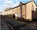
1
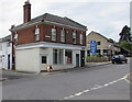
Corner shop to let in Lydney
The empty shop on the corner of Swan Road and Hill Street is to let in late May 2016.
It was formerly a motorcycle clothing shop.
Image: © Jaggery
Taken: 22 May 2016
0.00 miles
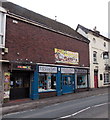
2
Zelish on a Lydney corner
In April 2018 Zelish hair salon is at 22 Hill Street on the corner of Swan Road.
Zelish was formerly at 5 Newerne Street, seen here https://www.geograph.org.uk/photo/4990518 in May 2016.
Image: © Jaggery
Taken: 15 Apr 2018
0.00 miles
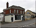
3
Taxicabs office in Lydney
On the right at 20A Hill Street, next door to Zelish https://www.geograph.org.uk/photo/5739813 on the corner of Swan Road.
Image: © Jaggery
Taken: 15 Apr 2018
0.00 miles
4
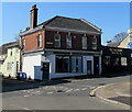
Zelish at 22 Hill Street, Lydney
Zelish hair salon is on the corner of Hill Street and Swan Road.
NG Thai Food is on the right in May 2021.
Image: © Jaggery
Taken: 2 May 2021
0.00 miles
5
The Ugly Duckling Country Restaurant, Lydney
Viewed across Swan Road looking towards Hill Street and Newerne Street. The restaurant is adjacent to The Swan Hotel http://www.geograph.org.uk/photo/1939632 and occupies the area that was formerly The Swan's skittle alley.
Image: © Jaggery
Taken: 1 Jan 2013
0.00 miles
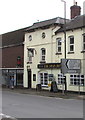
6
Newerne Street businesses, Lydney
Looking towards The Swan Hotel http://www.geograph.org.uk/photo/1939632 on the corner of Swan Road.
From left to right are Rubix nightclub, Essential Hair & Beauty and The Barber Shop.
Image: © Jaggery
Taken: 1 Jan 2013
0.00 miles
7
B4234 distances from the Swan Hotel, Lydney
The sign pointing towards the B4234 Forest Road shows
Dean Forest Steam Railway 1 (mile), Whitecroft 2½, Parkend 3½, Lydbrook 9.
Image: © Jaggery
Taken: 22 May 2016
0.00 miles
8

Direction signs outside the Swan Hotel, Lydney
Turn left for Gloucester, right for Chepstow. The dark green signs showing A48 date from the time when the A48 went through the centre of Lydney. In 2016 the route of the A48 bypasses Lydney, to the south and east. This road past the Swan is now unclassified.
The signs face Forest Road at the southern end of the B4234, a north-south road extending for 27km through the Forest of Dean.
Image: © Jaggery
Taken: 22 May 2016
0.00 miles
9
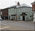
Swan Hotel, Lydney
On the corner of Swan Road and Newerne Street viewed in April 2018.
The Swan has had a colour change since this https://www.geograph.org.uk/photo/1939632 June 2010 photo.
Image: © Jaggery
Taken: 15 Apr 2018
0.00 miles
10
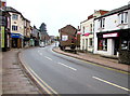
Bend in the road through Lydney town centre
Looking west along Newerne Street towards Hill Street.
Now unclassified, this route was formerly part of the A48.
The present-day A48 bypasses central Lydney.
Image: © Jaggery
Taken: 15 Apr 2018
0.00 miles