IMAGES TAKEN NEAR TO
Old Furnace Close, LYDNEY, GL15 5FB
Introduction
This page details the photographs taken nearby to Old Furnace Close, GL15 5FB by members of the Geograph project.
The Geograph project started in 2005 with the aim of publishing, organising and preserving representative images for every square kilometre of Great Britain, Ireland and the Isle of Man.

There are currently over 7.5m images from over14,400 individuals and you can help contribute to the project by visiting https://www.geograph.org.uk
Image Map
Images are licensed for reuse under creativecommons.org/licenses/by-sa/2.0
Notes
- Clicking on the map will re-center to the selected point.
- The higher the marker number, the further away the image location is from the centre of the postcode.
Image Listing (203 Images Found)
Images are licensed for reuse under creativecommons.org/licenses/by-sa/2.0
Image
Details
Distance
1
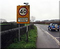
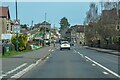
40 - Please drive carefully, Lydney
The 30mph speed limit on High Street increases to 40mph. Ahead for the A48 Lydney Bypass.
Image: © Jaggery
Taken: 5 Jan 2020
0.03 miles
2
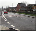
Start of the 30 zone at the SW edge of High Street, Lydney
The 40mph speed limit drops to 30mph. The broken white lines are at the Watery Lane junction.
Image: © Jaggery
Taken: 5 Jan 2020
0.03 miles
3
Lydney boundary sign
The unnamed connecting road NE from the A48 reaches Lydney. The boundary sign is on the corner of Watery Lane. http://www.geograph.org.uk/photo/3301254 High Street is ahead.
Image: © Jaggery
Taken: 1 Jan 2013
0.03 miles
4
Access road to Old Town Mews and Old Furnace Close, Lydney
From High Street. Turn left ahead for Old Town Mews, right for Old Furnace Close.
Image: © Jaggery
Taken: 5 Jan 2020
0.04 miles
5
Names on Lydney fences
In the background here. https://www.geograph.org.uk/photo/6367122
The Old Town Mews name sign is on the left.
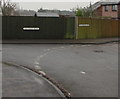
The Old Furnace Close name sign is on the right.
Image: © Jaggery
Taken: 5 Jan 2020
0.04 miles
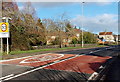
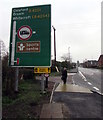
6
Lydney Cycleway Improvements sign, Watery Lane, Lydney
Located near the corner of High Street, this is one of several similar temporary signs in Lydney in January 2020.
Image: © Jaggery
Taken: 5 Jan 2020
0.04 miles
7
Directions sign on the approach to High Street, Lydney
Near the corner of Watery Lane.
Image: © Jaggery
Taken: 5 Jan 2020
0.04 miles
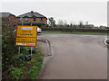
8
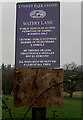
Lydney Park Estate notice, Watery Lane, Lydney
Located here. https://www.geograph.org.uk/photo/6362094
Image: © Jaggery
Taken: 5 Jan 2020
0.04 miles
9
Lydney : High Street
Looking along the High Street.
Image: © Lewis Clarke
Taken: 22 Mar 2023
0.04 miles
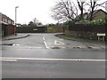
10
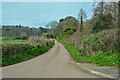
Lydney : Watery Lane
Looking along Watery Lane off High Street.
Image: © Lewis Clarke
Taken: 22 Mar 2023
0.05 miles