IMAGES TAKEN NEAR TO
Harrison Way, LYDNEY, GL15 5BH
Introduction
This page details the photographs taken nearby to Harrison Way, GL15 5BH by members of the Geograph project.
The Geograph project started in 2005 with the aim of publishing, organising and preserving representative images for every square kilometre of Great Britain, Ireland and the Isle of Man.

There are currently over 7.5m images from over14,400 individuals and you can help contribute to the project by visiting https://www.geograph.org.uk
Image Map
Images are licensed for reuse under creativecommons.org/licenses/by-sa/2.0
Notes
- Clicking on the map will re-center to the selected point.
- The higher the marker number, the further away the image location is from the centre of the postcode.
Image Listing (7 Images Found)
Images are licensed for reuse under creativecommons.org/licenses/by-sa/2.0
Image
Details
Distance
1
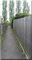
Public footpath
The footpath that leads onto the old Lydney golf course
Image: © Gill
Taken: 8 May 2015
0.09 miles
2
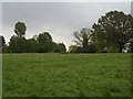
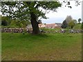
Golf course
The remaining part of the old Lydney golf course, now a haven for walkers and dogs.
Image: © Gill
Taken: 8 May 2015
0.12 miles
3
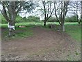
Old Lydney golf course
Where kids have built some sort of bmx or karting track around the trees
Image: © Gill
Taken: 8 May 2015
0.15 miles
4
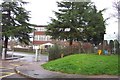
Severnbanks Primary School, Lydney
Image: © Jonathan Billinger
Taken: 4 Dec 2006
0.18 miles
5
Old Lydney golf club
The completely demolished remains of the club house, badly damaged in a fire in August of 2011. In the background are some of the new houses built on the partial site of the old golf course.
Image: © Gill
Taken: 8 May 2015
0.22 miles
6
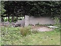
Lydney old golf course
Where they used to store the sand for the bunkers, I think.
Image: © Gill
Taken: 8 May 2015
0.23 miles
7
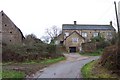
Crump Farm
Down a lane out of Lydney.
Image: © Jonathan Billinger
Taken: 4 Dec 2006
0.23 miles