IMAGES TAKEN NEAR TO
Jubilee Road, LYDNEY, GL15 5AR
Introduction
This page details the photographs taken nearby to Jubilee Road, GL15 5AR by members of the Geograph project.
The Geograph project started in 2005 with the aim of publishing, organising and preserving representative images for every square kilometre of Great Britain, Ireland and the Isle of Man.

There are currently over 7.5m images from over14,400 individuals and you can help contribute to the project by visiting https://www.geograph.org.uk
Image Map
Images are licensed for reuse under creativecommons.org/licenses/by-sa/2.0
Notes
- Clicking on the map will re-center to the selected point.
- The higher the marker number, the further away the image location is from the centre of the postcode.
Image Listing (50 Images Found)
Images are licensed for reuse under creativecommons.org/licenses/by-sa/2.0
Image
Details
Distance
1
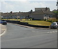
Bungalows, Klondyke Avenue, Lydney
A few of the c100 small semi-detached bungalows built by the rural district council on Klondyke Avenue in the mid 1950s.
Image: © Jaggery
Taken: 26 Jun 2010
0.14 miles
2
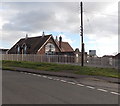
Youth and Community Centre, Lydney
Located on the south side of Naas Lane.
Image: © Jaggery
Taken: 1 Jan 2013
0.15 miles
3
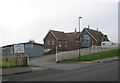
Community Centre and Sea Cadet Corps
Naas Lane, Lydney.
Image: © Pauline E
Taken: 11 Oct 2007
0.15 miles
4
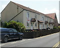
Houses, Tutnalls Street, Lydney
Located between Klondyke Avenue and Pylers Way. The building at the far end of the row is Lydney United Reformed Church.http://www.geograph.org.uk/photo/1939756
The England flag hanging from the window is on display during a brief period of optimism, the day before England's departure from the 2010 football World Cup after a 4-1 defeat by Germany.
Image: © Jaggery
Taken: 26 Jun 2010
0.16 miles
5
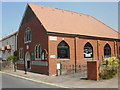
Lydney United Reformed Church
Looking like a recently built church, this red brick building dates from 1928, replacing a corrugated iron structure sometimes referred to as "The Tin Chapel" on this site on Tutnalls Street, near the corner of Pylers Way.
Image: © Jaggery
Taken: 26 Jun 2010
0.16 miles
6
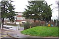
Severnbanks Primary School, Lydney
Image: © Jonathan Billinger
Taken: 4 Dec 2006
0.18 miles
7
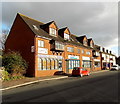
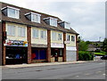
Row of shops, Hams Road, Lydney
Located opposite Lydney Bus Station.
Image: © Jaggery
Taken: 1 Jan 2013
0.18 miles
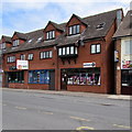
8
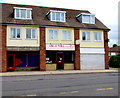
Great Wall takeaway, Lydney
Chinese (Peking & Cantonese cuisine) takeaway at 3 Hams Road, opposite Lydney bus station.
Image: © Jaggery
Taken: 22 May 2016
0.18 miles
9
Rominos, Lydney
Takeaway (pizzas, kebabs, burgers etc) viewed across Hams Road.
Image: © Jaggery
Taken: 22 May 2016
0.19 miles
10
The Number 9 shop in Lydney
Number 9 shop at 19 Hams Road sells baby-related items
such as secondhand pushchairs, handmade knitted items etc.
Image: © Jaggery
Taken: 22 May 2016
0.19 miles