IMAGES TAKEN NEAR TO
Bracken Drive, LYDNEY, GL15 5AQ
Introduction
This page details the photographs taken nearby to Bracken Drive, GL15 5AQ by members of the Geograph project.
The Geograph project started in 2005 with the aim of publishing, organising and preserving representative images for every square kilometre of Great Britain, Ireland and the Isle of Man.

There are currently over 7.5m images from over14,400 individuals and you can help contribute to the project by visiting https://www.geograph.org.uk
Image Map
Images are licensed for reuse under creativecommons.org/licenses/by-sa/2.0
Notes
- Clicking on the map will re-center to the selected point.
- The higher the marker number, the further away the image location is from the centre of the postcode.
Image Listing (97 Images Found)
Images are licensed for reuse under creativecommons.org/licenses/by-sa/2.0
Image
Details
Distance
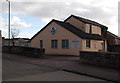
1
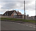
Youth and Community Centre, Lydney
Located on the south side of Naas Lane.
Image: © Jaggery
Taken: 1 Jan 2013
0.11 miles
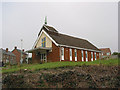
2
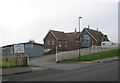
Community Centre and Sea Cadet Corps
Naas Lane, Lydney.
Image: © Pauline E
Taken: 11 Oct 2007
0.11 miles
3
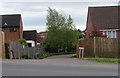
Highfield Rise, Lydney
Cul-de-sac on the east side of Highfield Road, nearly opposite Meadow Rise. http://www.geograph.org.uk/photo/5352547
Image: © Jaggery
Taken: 16 Apr 2017
0.13 miles
4
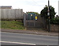
Highfield electricity substation, Lydney
The Western Power Distribution electricity substation is the dark green cabinet
inside an enclosure on the southeast side of Highfield Road. Its identifier is HIGHFIELD 2855.
Image: © Jaggery
Taken: 16 Apr 2017
0.13 miles
5
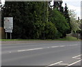
Directions sign facing Highfield Road, Lydney
On the descent to the town centre.
Image: © Jaggery
Taken: 16 Apr 2017
0.14 miles
7
Severnside Veterinary Centre, Lydney
On the corner of Naas Lane and Tutnalls Street, next door to The Greyhound. http://www.geograph.org.uk/photo/3569669
Image: © Jaggery
Taken: 1 Jan 2013
0.14 miles
8
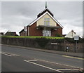
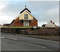
Catholic Church of St Joseph, Lydney
Viewed across Highfield Road from the corner of Albert Street.
The church at the edge of the town centre is part of the Roman Catholic Diocese of Clifton.
Image: © Jaggery
Taken: 16 Apr 2017
0.15 miles
9
Catholic Church of St Joseph, Lydney
Viewed across Highfield Road from the corner of Albert Street.
Image: © Jaggery
Taken: 1 Jan 2013
0.15 miles
10
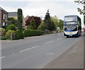
Stagecoach double-decker bus descends Highfield Road, Lydney
On Easter Sunday April 16th 2017, Stagecoach bus number 15876 is on route 23 from Gloucester to Coleford via Minsterworth, Westbury-on-Severn, Newnham, Blakeney, Lydney Bus Station, Yorkley, Whitecroft, Bream, Sling and Milkwall.
Image: © Jaggery
Taken: 16 Apr 2017
0.15 miles