IMAGES TAKEN NEAR TO
Harveys Lane, LYDNEY, GL15 4SZ
Introduction
This page details the photographs taken nearby to Harveys Lane, GL15 4SZ by members of the Geograph project.
The Geograph project started in 2005 with the aim of publishing, organising and preserving representative images for every square kilometre of Great Britain, Ireland and the Isle of Man.

There are currently over 7.5m images from over14,400 individuals and you can help contribute to the project by visiting https://www.geograph.org.uk
Image Map
Images are licensed for reuse under creativecommons.org/licenses/by-sa/2.0
Notes
- Clicking on the map will re-center to the selected point.
- The higher the marker number, the further away the image location is from the centre of the postcode.
Image Listing (30 Images Found)
Images are licensed for reuse under creativecommons.org/licenses/by-sa/2.0
Image
Details
Distance
1
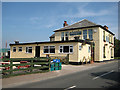
The Bailey Inn, Yorkley
Situated on the junction of Stag Hill, Bailey Hill and Yorkley Lane. Taken from Yorkley Lane.
Image: © Pauline E
Taken: 24 Jul 2008
0.02 miles
2
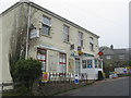
The Forester - and Post Office
On George Road.
Image: © M J Richardson
Taken: 24 Sep 2013
0.03 miles
3
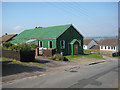
Band room, Stag Hill, Yorkley
Forest of Dean Brass practise here twice a week. The band was formed when Yorkley Onward Band merged with Coleford Brass in the early 1990s.
Image: © Pauline E
Taken: 24 Jul 2008
0.04 miles
4
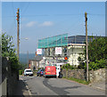
Yorkley Post Office
In Stag Hill, undergoing renovation. The mailvan has just pulled up.
Image: © Pauline E
Taken: 24 Jul 2008
0.04 miles
5
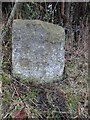
Boundary Stone, Yorkley
In Lydney Road just South of Southdene House, set back from the road. It has been labelled "BS" on many OS maps until 1958 when just "stone". It is at an inflexion of the boundary for the Royal Forest of Dean with some apparent inscription that may have been deliberately defaced during WWII as was the requirement of the Government.
It differs from all other "Forest" boundary stones, eg see https://www.geograph.org.uk/article/Royal-Forest-of-Dean-Boundary-Stones
Milestone Society National ID: GL_WDEAN11bm
Image: © Mr Red
Taken: 23 Dec 2024
0.05 miles
6
Yorkley Primary School
Situated in Yorkley Lane and currently closed for the summer holidays.
Image: © Pauline E
Taken: 24 Jul 2008
0.06 miles
7
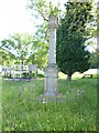
Yorkley War Memorial
Located in the recreation grounds, close to the road
Image: © John C
Taken: 21 Jun 2013
0.07 miles
8
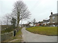
Beech Road, Yorkley
Part of the network of small roads in this Forest of Dean community.
Image: © Jonathan Billinger
Taken: 10 Mar 2010
0.13 miles
9
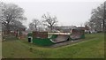
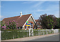
Yorkley community centre
In the foreground is a skate board area in need of some TLC.
Image: © Jonathan Billinger
Taken: 17 Dec 2019
0.13 miles
10
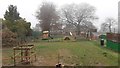
Yorkley children's playground
Adjacent to the community centre.
The beech tree in the foreground has just been planted.
Image: © Jonathan Billinger
Taken: 17 Dec 2019
0.14 miles