IMAGES TAKEN NEAR TO
Johnsons Way, LYDNEY, GL15 4RZ
Introduction
This page details the photographs taken nearby to Johnsons Way, GL15 4RZ by members of the Geograph project.
The Geograph project started in 2005 with the aim of publishing, organising and preserving representative images for every square kilometre of Great Britain, Ireland and the Isle of Man.

There are currently over 7.5m images from over14,400 individuals and you can help contribute to the project by visiting https://www.geograph.org.uk
Image Map
Images are licensed for reuse under creativecommons.org/licenses/by-sa/2.0
Notes
- Clicking on the map will re-center to the selected point.
- The higher the marker number, the further away the image location is from the centre of the postcode.
Image Listing (11 Images Found)
Images are licensed for reuse under creativecommons.org/licenses/by-sa/2.0
Image
Details
Distance
1
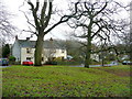
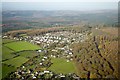
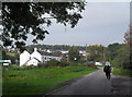
Cottages at Yorkley Slade
This village is situated on the southern fringe of the Forest of Dean.
Image: © Jonathan Billinger
Taken: 12 Dec 2011
0.07 miles
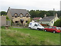
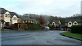
4
Houses at Yorkley Slade
At the corner of Harold Road and Tylers Way.
Image: © M J Richardson
Taken: 27 Sep 2013
0.11 miles
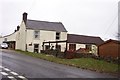
6
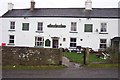
The Nag's Head at Yorkley Slade
A quiet Monday lunchtime.
Image: © Jonathan Billinger
Taken: 4 Dec 2006
0.16 miles
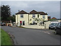
7
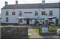
The Nag's Head at Yorkley Slade, 2020
The pub is open with Covid-19 warnings on this Wednesday afternoon in September.
This is my re-visitation of the first Geograph for this square taken in December 2006.
See: Image
Image: © Jonathan Billinger
Taken: 16 Sep 2020
0.16 miles
8
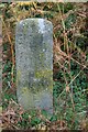
Old Milestone by Yorkley Slade, West Dean
Carved stone post by the UC road, in parish of West Dean (Forest of Dean District), East of Yorkley, on grass verge, on North-east side of road. Passage stone erected by the Forest of Dean Turnpike Trust in the 19th century.
The eroded or defaced inscription once read:-
(Coleford 6)
(Purton Passage 3)
Milestone Society National ID: GL_COPU06.
Image: © Milestone Society
Taken: 13 Oct 2018
0.16 miles
9
Towards Yorkley Slade
The Nags Head pub is on the left.
Image: © Des Blenkinsopp
Taken: 11 Oct 2010
0.17 miles
10
The Ridgeway, Yorkley Slade
Newish housing on the fringe of the Forest of Dean.
Image: © Jonathan Billinger
Taken: 12 Dec 2011
0.19 miles