IMAGES TAKEN NEAR TO
Grove Road, LYDNEY, GL15 4QL
Introduction
This page details the photographs taken nearby to Grove Road, GL15 4QL by members of the Geograph project.
The Geograph project started in 2005 with the aim of publishing, organising and preserving representative images for every square kilometre of Great Britain, Ireland and the Isle of Man.

There are currently over 7.5m images from over14,400 individuals and you can help contribute to the project by visiting https://www.geograph.org.uk
Image Map
Images are licensed for reuse under creativecommons.org/licenses/by-sa/2.0
Notes
- Clicking on the map will re-center to the selected point.
- The higher the marker number, the further away the image location is from the centre of the postcode.
Image Listing (53 Images Found)
Images are licensed for reuse under creativecommons.org/licenses/by-sa/2.0
Image
Details
Distance
1
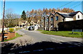
Grove Road, Whitecroft
The SE end of Grove Road viewed across Pillowell Road.
Image: © Jaggery
Taken: 16 Mar 2014
0.02 miles
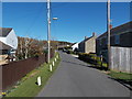
2
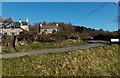
Charleswood Road, Whitecroft
Charleswood Road climbs away from Pillowell Road.
Image: © Jaggery
Taken: 16 Mar 2014
0.03 miles
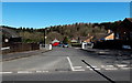
3
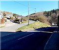
Junction in Whitecroft
Charleswood Road in sunshine on the left, Pillowell Road in shadow on the right.
Image: © Jaggery
Taken: 16 Mar 2014
0.04 miles
4
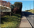
Whitecroft boundary sign
In the Forest of Dean (west Gloucestershire), Pillowell Road passes from Pillowell into Whitecroft.
Image: © Jaggery
Taken: 16 Mar 2014
0.05 miles
5
Wesley Road, Whitecroft
Looking towards Pillowell Road.
Image: © Jaggery
Taken: 16 Mar 2014
0.06 miles
6
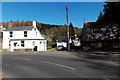
Formerly The Swan, Pillowell
Viewed in March 2014. The white house used to be The Swan (Inn).
The name signs seen in this http://www.geograph.org.uk/photo/895311 view taken in July 2008 have been removed.
Image: © Jaggery
Taken: 16 Mar 2014
0.08 miles
7
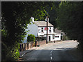
Swan Inn
Between Pillowell and Whitecroft.
Image: © Pauline E
Taken: 24 Jul 2008
0.08 miles
8
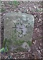
Gale Stone, Yorkley
A boundary marker defining traditional Royal Forest of Dean mining right dating from the 1840's.
In Oakenhill Wood, Phipps Bottom area, Forestry land, with pedestrian access.
Inscription: 75
Milestone Society National ID: tbc
Image: © Owen McLaughlin
Taken: 17 Jan 2025
0.10 miles
9
Bath Crescent, Whitecroft
Viewed across Pillowell Road. Bath Crescent leads to High Delf Way which leads to Grove Park.
Image: © Jaggery
Taken: 16 Mar 2014
0.12 miles
10
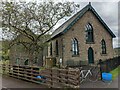
Former chapel in Whitecroft
Former Whitecroft Wesleyan Methodist Chapel now converted into apartments. One of the churches and chapels within 25km of home that I am visiting by bike.
Image: © Andy Stott
Taken: 22 May 2021
0.13 miles