IMAGES TAKEN NEAR TO
Woodland Close, LYDNEY, GL15 4PL
Introduction
This page details the photographs taken nearby to Woodland Close, GL15 4PL by members of the Geograph project.
The Geograph project started in 2005 with the aim of publishing, organising and preserving representative images for every square kilometre of Great Britain, Ireland and the Isle of Man.

There are currently over 7.5m images from over14,400 individuals and you can help contribute to the project by visiting https://www.geograph.org.uk
Image Map
Images are licensed for reuse under creativecommons.org/licenses/by-sa/2.0
Notes
- Clicking on the map will re-center to the selected point.
- The higher the marker number, the further away the image location is from the centre of the postcode.
Image Listing (127 Images Found)
Images are licensed for reuse under creativecommons.org/licenses/by-sa/2.0
Image
Details
Distance
1
Western arm of Park Hill, Whitecroft
Park Hill follows a roughly rectangular course. This section is near Whitecroft Road. http://www.geograph.org.uk/photo/3888669
Image: © Jaggery
Taken: 16 Mar 2014
0.07 miles
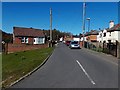
2
Northern arm of Park Hill, Whitecroft
Park Hill follows a roughly rectangular course. This section was viewed
from the corner of Pillowell Road. The red bin is outside Al's Plaice. http://www.geograph.org.uk/photo/3888508
Image: © Jaggery
Taken: 16 Mar 2014
0.07 miles
4
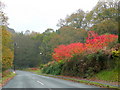
Park Hill, Whitecroft
The Sumac (Rhus typhina) on the right is going out in a blaze of colour on this dull November day.
Image: © Jonathan Billinger
Taken: 6 Nov 2009
0.11 miles
5
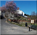
Early spring blossom in Whitecroft
With clear blue skies, warm sunshine and much blossom to be seen, Sunday March 16th 2014 in Whitecroft felt more like mid May than mid March. This view was taken from the edge of Park Hill near the Pillowell Road junction.
Image: © Jaggery
Taken: 16 Mar 2014
0.11 miles
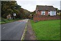
6
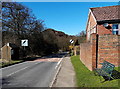
Whitecroft Road bench and bus shelter, Whitecroft
Viewed from the corner of Park Hill, at the NW edge of Whitecroft. Ahead, the speed limit
increases from 30mph to the National Speed Limit along the road to Bream.
Image: © Jaggery
Taken: 16 Mar 2014
0.11 miles
7
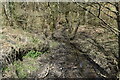
Stream below Whitecroft Road
Close to the site of the former Princess Royal Colliery.
Image: © David Martin
Taken: 3 Apr 2022
0.11 miles
8
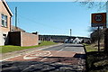
Start of the 30mph zone in Whitecroft
The National Speed Limit along the road from Bream reduces to 30mph at the NW edge of Whitecroft.
Image: © Jaggery
Taken: 16 Mar 2014
0.12 miles
9
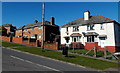
Park Hill houses, Whitecroft
Viewed from the entrance http://www.geograph.org.uk/photo/3888641 to The Royal Oak.
Image: © Jaggery
Taken: 16 Mar 2014
0.12 miles
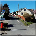
10
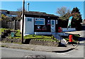
Al's Plaice, Whitecroft
Fish & chips and other takeaway food shop on the corner of Park Hill and Pillowell Road.
Image: © Jaggery
Taken: 16 Mar 2014
0.12 miles