IMAGES TAKEN NEAR TO
Meadow Close, LYDNEY, GL15 4NX
Introduction
This page details the photographs taken nearby to Meadow Close, GL15 4NX by members of the Geograph project.
The Geograph project started in 2005 with the aim of publishing, organising and preserving representative images for every square kilometre of Great Britain, Ireland and the Isle of Man.

There are currently over 7.5m images from over14,400 individuals and you can help contribute to the project by visiting https://www.geograph.org.uk
Image Map
Images are licensed for reuse under creativecommons.org/licenses/by-sa/2.0
Notes
- Clicking on the map will re-center to the selected point.
- The higher the marker number, the further away the image location is from the centre of the postcode.
Image Listing (24 Images Found)
Images are licensed for reuse under creativecommons.org/licenses/by-sa/2.0
Image
Details
Distance
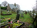
1
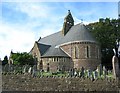
Viney Hill Church
The parish church at Viney Hill. looking north-west.
Image: © Dave Bushell
Taken: 9 Oct 2005
0.06 miles
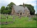
2
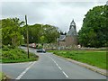
All Saints Church at Viney Hill
Road junction at Viney Hill with All Saints Church on right.
Image: © Clint Mann
Taken: 11 May 2014
0.08 miles
3
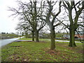
Viney Hill
A community centred around quarrying on the southern edge of the Forest of Dean.
Image: © Jonathan Billinger
Taken: 30 Mar 2010
0.08 miles
4
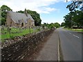
All Saints Church, Viney Hill
A minor road passing All Saints Church on Viney Hill.
Image: © Philip Halling
Taken: 18 Aug 2020
0.09 miles
5
All Saints' church, Viney Hill
Looking from the south-west.
Image: © Jonathan Billinger
Taken: 30 Mar 2010
0.10 miles
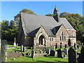
6
All Saints Church, Viney Hill
All Saints church at Viney Hill was built in 1865-7 and designed by Ewan Christian for Mary Bathurst of Lydney Park. The church is Grade II listed, see: https://historicengland.org.uk/listing/the-list/list-entry/1186403
Image: © Philip Halling
Taken: 18 Aug 2020
0.10 miles
7
All Saints Church at Viney Hill
Viewed from the south-west.
Image: © Peter Wood
Taken: 16 Oct 2016
0.10 miles
8
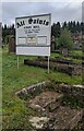
All Saints nameboard, Viney Hill, Gloucestershire
Facing Main Road near the churchyard entrance path https://www.geograph.org.uk/photo/7635272
Image: © Jaggery
Taken: 22 Oct 2023
0.10 miles
9
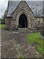
Church porch, Viney Hill, Gloucestershire
In the SW corner of All Saints Church in the Church of England Diocese of Gloucester.
Image: © Jaggery
Taken: 22 Oct 2023
0.10 miles
10
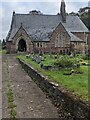
South side of All Saints, Viney Hill, Gloucestershire
Grade II Listed All Saints Church in the Church of England Diocese of Gloucester.
Image: © Jaggery
Taken: 22 Oct 2023
0.10 miles