IMAGES TAKEN NEAR TO
St. Swithins Road, LYDNEY, GL15 4NF
Introduction
This page details the photographs taken nearby to St. Swithins Road, GL15 4NF by members of the Geograph project.
The Geograph project started in 2005 with the aim of publishing, organising and preserving representative images for every square kilometre of Great Britain, Ireland and the Isle of Man.

There are currently over 7.5m images from over14,400 individuals and you can help contribute to the project by visiting https://www.geograph.org.uk
Image Map
Images are licensed for reuse under creativecommons.org/licenses/by-sa/2.0
Notes
- Clicking on the map will re-center to the selected point.
- The higher the marker number, the further away the image location is from the centre of the postcode.
Image Listing (10 Images Found)
Images are licensed for reuse under creativecommons.org/licenses/by-sa/2.0
Image
Details
Distance
1
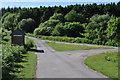
Looking down Oldcroft Road
Image: © Nick Mutton 01329 000000
Taken: 16 Jun 2010
0.05 miles
3
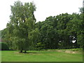
Oldcroft Plantation
Two old birches and roadside oaks, part of the Forest of Dean between Oldcroft and Viney Hill.
Image: © M J Richardson
Taken: 27 Sep 2013
0.08 miles
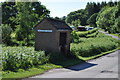
4
Telephone kiosk at Oldcroft
Image: © Nick Mutton 01329 000000
Taken: 16 Jun 2010
0.11 miles
5
![Sweet chestnut [Castanea sativa]](https://s2.geograph.org.uk/geophotos/03/68/43/3684330_f0b63ade_120x120.jpg)
Sweet chestnut [Castanea sativa]
Spiky fruits contain shiny brown seeds, and the toothed edges of the leaves are characteristic. For the whole tree see Image
Image: © M J Richardson
Taken: 27 Sep 2013
0.11 miles
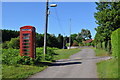
6
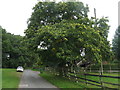
Church Walk
Looking towards Viney Hill, with a fine fruiting Sweet chestnut - for detail see Image
Image: © M J Richardson
Taken: 27 Sep 2013
0.12 miles
7
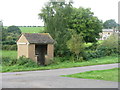
Bus shelter at Clockhouse Tump
Tump, a frequent place name around the Forest of Dean, is a small rounded hill or mound; a tumulus; or a clump of trees, shrubs, or grass.
Image: © M J Richardson
Taken: 27 Sep 2013
0.14 miles
9
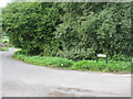
Bend in the road at Neds Top
At Oldcroft.
Image: © M J Richardson
Taken: 27 Sep 2013
0.18 miles
10
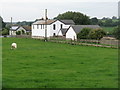
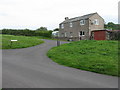
Houses at Needs Top
A variant of the spelling on the map - all others are 'Nedstop'.
Image: © M J Richardson
Taken: 27 Sep 2013
0.25 miles