IMAGES TAKEN NEAR TO
Purlieu, LYDNEY, GL15 4LW
Introduction
This page details the photographs taken nearby to Purlieu, GL15 4LW by members of the Geograph project.
The Geograph project started in 2005 with the aim of publishing, organising and preserving representative images for every square kilometre of Great Britain, Ireland and the Isle of Man.

There are currently over 7.5m images from over14,400 individuals and you can help contribute to the project by visiting https://www.geograph.org.uk
Image Map
Images are licensed for reuse under creativecommons.org/licenses/by-sa/2.0
Notes
- Clicking on the map will re-center to the selected point.
- The higher the marker number, the further away the image location is from the centre of the postcode.
Image Listing (7 Images Found)
Images are licensed for reuse under creativecommons.org/licenses/by-sa/2.0
Image
Details
Distance
1
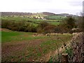
View over Farmland nr Lydney
View looking N towards Viney Hill.
Image: © Stuart Wilding
Taken: 30 Mar 2006
0.06 miles
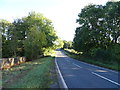
3
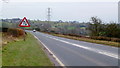
A48 between Blakeney and Lydney
Looking north-east towards Blakeney, Newnham and Gloucester.
Image: © Jonathan Billinger
Taken: 8 Feb 2012
0.13 miles
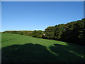
4
Yes?
These sheep are totally at home here by Lensbrook Road; the look they gave me as I came to geograph the square was "Why bother?"
Image: © Jonathan Billinger
Taken: 26 Aug 2011
0.17 miles
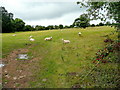
6
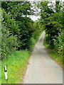
Lensbrook Road
Looking north towards Blakeney.
Image: © Jonathan Billinger
Taken: 26 Aug 2011
0.18 miles
7
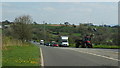
A48 between Blakeney and Lydney
The main road in spring sunshine over seven years since the previous Geograph for this square; Image
Image: © Jonathan Billinger
Taken: 12 Apr 2019
0.19 miles