IMAGES TAKEN NEAR TO
Church Drive, LYDNEY, GL15 4HJ
Introduction
This page details the photographs taken nearby to Church Drive, GL15 4HJ by members of the Geograph project.
The Geograph project started in 2005 with the aim of publishing, organising and preserving representative images for every square kilometre of Great Britain, Ireland and the Isle of Man.

There are currently over 7.5m images from over14,400 individuals and you can help contribute to the project by visiting https://www.geograph.org.uk
Image Map
Images are licensed for reuse under creativecommons.org/licenses/by-sa/2.0
Notes
- Clicking on the map will re-center to the selected point.
- The higher the marker number, the further away the image location is from the centre of the postcode.
Image Listing (243 Images Found)
Images are licensed for reuse under creativecommons.org/licenses/by-sa/2.0
Image
Details
Distance
1
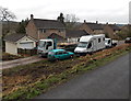
Church Drive houses, Parkend
Set back about 10 metres from the west side of the road.
Image: © Jaggery
Taken: 6 Apr 2014
0.01 miles
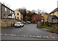
2
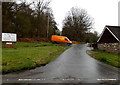
Church Drive, Parkend
Looking south from Yorkley Road. The board is for St Paul's Church, http://www.geograph.org.uk/photo/3918352 about 400 metres ahead.
Image: © Jaggery
Taken: 6 Apr 2014
0.04 miles
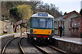
3
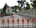
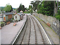
Waiting room and south bound platform, Parkend
A beautifully restored station on the Dean Forest Railway. All aboard for a nostalgic ride to Lydney Junction.
Image: © Pauline E
Taken: 20 May 2008
0.06 miles
4
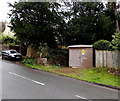
Yorkley Road electricity substation, Parkend
Located on the south side of Yorkley Road between Fairmoor Close and Church Drive. The identifier on the box is Parkend Hotel S/S 01097, though there was no hotel of that name nearby at the early April 2014 date of this view.
Image: © Jaggery
Taken: 6 Apr 2014
0.06 miles
5
Fairmoor Close, Parkend
A cul-de-sac on the south side of Yorkley Road.
Image: © Jaggery
Taken: 6 Apr 2014
0.06 miles
6
Parkend Railway Station, Gloucestershire
The station has regrown somewhat since the photo was taken. It is the northern terminus of the Forest of Dean Railway.
Image: © nick macneill
Taken: 17 Jun 1993
0.06 miles
7
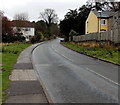
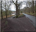
Yorkley Road, Parkend
Yorkley Road climbs away from New Road. Viewed from opposite the Fairmoor Close http://www.geograph.org.uk/photo/3918112 junction.
Image: © Jaggery
Taken: 6 Apr 2014
0.06 miles
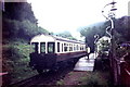
8
Parkend Station
DMU reaches the end of the line.
Image: © Stuart Wilding
Taken: 15 Mar 2009
0.07 miles
9
Parkend Station - end of the line
Compare to Image
After much work and restoration, Parkend Station was re-opened to the first regular passenger trains since 1929. The Dean Forest Railway runs on special occasions from Parkend to Lydney Junction.
Image: © Pauline E
Taken: 20 May 2008
0.07 miles
10
Access road to Church Drive houses, Parkend
The road on the left diverging from Church Drive leads to these http://www.geograph.org.uk/photo/3918303 houses.
Image: © Jaggery
Taken: 6 Apr 2014
0.07 miles