1
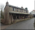
Old Corn Mill, Blakeney
Converted to residential use, located between Millend and Forge Brook.
Image: © Jaggery
Taken: 3 Feb 2013
0.02 miles
2
Numbers 1 and 2 The Mill, Blakeney
Former mill in Millend converted to two semi-detached houses.
Image: © Jaggery
Taken: 3 Feb 2013
0.05 miles
3
Millend, Blakeney
Looking south from the A48 High Street.
Image: © Jaggery
Taken: 3 Feb 2013
0.06 miles
4
Butlers Mead, Blakeney
Viewed from the Millend side of Butlers Mead.
Image: © Jaggery
Taken: 3 Feb 2013
0.08 miles
5
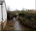
SE along Forge Brook Blakeney
Forge Brook flows southeastwards away from High Street.
Image: © Jaggery
Taken: 3 Feb 2013
0.08 miles
6
Railway bridge remains, Blakeney
On the approach to Blakeney station - only ever used for freight traffic, and not a great deal even of that - the Forest of Dean Central Railway crossed Millend, a minor road leading to Etloe and Purton. The span of the bridge is long gone but the abutments remain. The station site (now a housing development called "Old Station Road) is to the left of the shot.
Image: © John Winder
Taken: 7 Jun 2020
0.09 miles
7
Dean Mowers Ltd, Blakeney
Positioned on the High Street. Photographed from the adjoining square.
Image: © Pauline E
Taken: 20 May 2008
0.09 miles
8
Remains of a railway bridge, Millend, Blakeney
The stonework is the surviving part of a railway bridge that used to carry
a freight-only line, the Dean Central Railway, over Millend. The line closed in 1949.
Image: © Jaggery
Taken: 3 Feb 2013
0.10 miles
9
Butlers Mead Car Park, Blakeney
A small, free car park at the edge of Blakeney Primary School and Blakeney Pre-school.
Their name sign and banner are at the fence.
Image: © Jaggery
Taken: 3 Feb 2013
0.10 miles
10
Sydenham House Residential Home, Blakeney
Located in the High Street.
Image: © Pauline E
Taken: 20 May 2008
0.11 miles


