IMAGES TAKEN NEAR TO
High Street, BLAKENEY, GL15 4EB
Introduction
This page details the photographs taken nearby to High Street, GL15 4EB by members of the Geograph project.
The Geograph project started in 2005 with the aim of publishing, organising and preserving representative images for every square kilometre of Great Britain, Ireland and the Isle of Man.

There are currently over 7.5m images from over14,400 individuals and you can help contribute to the project by visiting https://www.geograph.org.uk
Image Map
Images are licensed for reuse under creativecommons.org/licenses/by-sa/2.0
Notes
- Clicking on the map will re-center to the selected point.
- The higher the marker number, the further away the image location is from the centre of the postcode.
Image Listing (143 Images Found)
Images are licensed for reuse under creativecommons.org/licenses/by-sa/2.0
Image
Details
Distance
1
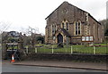
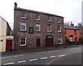
Blakeney Baptist Church
Viewed across High Street, Blakeney, the church is part of the West of England Baptist Association,
a grouping of c120 Baptist churches in Bath, Bristol, Cheltenham, Gloucester, Swindon and the rural areas of Gloucestershire, Somerset and Wiltshire. The West of England Baptist Association is one of thirteen Regional Associations which make up the Baptist Union of Great Britain.
Image: © Jaggery
Taken: 3 Feb 2013
0.01 miles
2
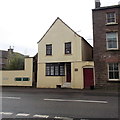
Waterloo House, Blakeney
High Street house facing the southern end of Cinderford Road.
Birmingham House is on the right. http://www.geograph.org.uk/photo/4024622
Image: © Jaggery
Taken: 3 Feb 2013
0.01 miles
3
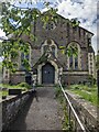
Blakeney Baptist Church
Blakeney Baptist Church was built in 1833 and was restored in 1874. Congregations of 250 attended services in 1851. One of my churches and chapels series. My aim is to cycle from home to all churches and chapels within 25km radius.
Image: © Andy Stott
Taken: 21 May 2021
0.02 miles
4
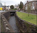
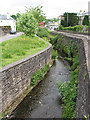
Blackpool Brook, Blakeney
Alongside High Street. The footbridge is near the Cinderford Road junction.
Image: © Jaggery
Taken: 3 Feb 2013
0.02 miles
5
Lion Witch & Lampshade, Blakeney
Located in Birmingham House, High Street. The nameboard shows that the business
includes decorative lighting, china & glass restoration and lampshades made to order.
Image: © Jaggery
Taken: 3 Feb 2013
0.02 miles
6
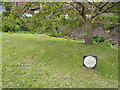
Commemorative plaque in Collins' Garden, Blakeney
This garden was the jubilee gift of Mr & Mrs SM Collins of Geraldtown, W. Australia to the parish.
1977 Jubilee
Image: © Pauline E
Taken: 20 May 2008
0.02 miles
7
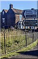
Scenic route directions, Blakeney, Gloucestershire
Facing the A48. Turn left into Cinderford Road for the scenic route to
Soudley (2½ (miles)) and Ruspidge (4). Turn left also for the scenic
route to the Dean Heritage Centre.
Image: © Jaggery
Taken: 28 Jul 2024
0.02 miles
8
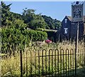
Undated Best Kept Village board, Blakeney, Gloucestershire
Alongside the A48.
Image: © Jaggery
Taken: 28 Jul 2024
0.02 miles
9
Brook channelled between two roads, Blakeney
Bridge Street on the left, the A48 on the right.
Image: © Pauline E
Taken: 20 May 2008
0.03 miles
10
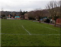
Towards Blakeney Primary School
Viewed from Butlers Mead Car Park http://www.geograph.org.uk/photo/3835491 looking across a sports field.
Image: © Jaggery
Taken: 3 Feb 2013
0.03 miles