IMAGES TAKEN NEAR TO
Church Way, BLAKENEY, GL15 4DT
Introduction
This page details the photographs taken nearby to Church Way, GL15 4DT by members of the Geograph project.
The Geograph project started in 2005 with the aim of publishing, organising and preserving representative images for every square kilometre of Great Britain, Ireland and the Isle of Man.

There are currently over 7.5m images from over14,400 individuals and you can help contribute to the project by visiting https://www.geograph.org.uk
Image Map
Images are licensed for reuse under creativecommons.org/licenses/by-sa/2.0
Notes
- Clicking on the map will re-center to the selected point.
- The higher the marker number, the further away the image location is from the centre of the postcode.
Image Listing (119 Images Found)
Images are licensed for reuse under creativecommons.org/licenses/by-sa/2.0
Image
Details
Distance
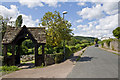
1
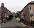
Unsuitable road for wide vehicles, Blakeney
The sign is at the southern end of Church Way, on the corner of All Saints Road.
How wide is not specified.
Image: © Jaggery
Taken: 3 Feb 2013
0.04 miles
2
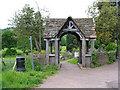
Memorial lych gate, Blakeney
The cemetery is a short distance from All Saints Church in All Saints Road. To the left of the gate, a footpath leads to the recreation ground.
Image: © Pauline E
Taken: 20 May 2008
0.05 miles
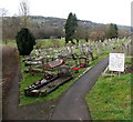
3
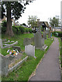
Cemetery, Blakeney
With memorial lych gate. The top of the tower of All Saints Church can just be seen.
Image: © Pauline E
Taken: 20 May 2008
0.05 miles
4
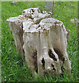
Beautifully weathered stump, Blakeney Cemetery
A lovely silvery colour in the hazy sunlight.
Image: © Pauline E
Taken: 20 May 2008
0.05 miles
5
All Saints Road cemetery, Blakeney
Viewed from the edge of the entrance lych gate. http://www.geograph.org.uk/photo/812761 The sign on the right shows Awre Parish Council. The village of Blakeney is the largest community in the civil parish of Awre which also includes the hamlets of Awre, Etloe, Gatcombe, Two Bridges and Viney Hill.
Image: © Jaggery
Taken: 3 Feb 2013
0.06 miles
6
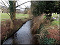
Forge Brook flows past a cemetery, Blakeney
Viewed from this footbridge. http://www.geograph.org.uk/photo/3319018
The cemetery http://www.geograph.org.uk/photo/3318969 on the right extends from All Saints Road. There is a recreation ground on the left.
Image: © Jaggery
Taken: 3 Feb 2013
0.06 miles
7
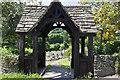
Lychgate, Blakeney
Leading to the cemetery.
Image: © Stuart Wilding
Taken: 3 Aug 2014
0.06 miles
8
Lychgate, Blakeney
Leading to the cemetery.
Image: © Stuart Wilding
Taken: 3 Aug 2014
0.07 miles
9
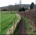
Track from All Saints Road to Forge Brook, Blakeney
The hedge is at the southern perimeter of this cemetery. http://www.geograph.org.uk/photo/3318969 The track was very muddy and slippery today. More than once, I had to use the fence on the left for support.
Image: © Jaggery
Taken: 3 Feb 2013
0.07 miles
10
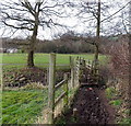
Footbridge over Forge Brook, Blakeney
The bridge is at the southern edge of this track. http://www.geograph.org.uk/photo/3318999 There is a recreation area on the far side.
Image: © Jaggery
Taken: 3 Feb 2013
0.07 miles