IMAGES TAKEN NEAR TO
Moorfield Avenue, BLAKENEY, GL15 4DA
Introduction
This page details the photographs taken nearby to Moorfield Avenue, GL15 4DA by members of the Geograph project.
The Geograph project started in 2005 with the aim of publishing, organising and preserving representative images for every square kilometre of Great Britain, Ireland and the Isle of Man.

There are currently over 7.5m images from over14,400 individuals and you can help contribute to the project by visiting https://www.geograph.org.uk
Image Map
Images are licensed for reuse under creativecommons.org/licenses/by-sa/2.0
Notes
- Clicking on the map will re-center to the selected point.
- The higher the marker number, the further away the image location is from the centre of the postcode.
Image Listing (117 Images Found)
Images are licensed for reuse under creativecommons.org/licenses/by-sa/2.0
Image
Details
Distance
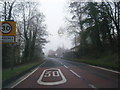
1
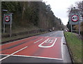
End of the 30 zone through Blakeney
Beyond the SW edge of the village, the speed limit on the A48 increases from 30mph to 40mph.
Image: © Jaggery
Taken: 3 Feb 2013
0.03 miles
2
Jogging out of Blakeney
The jogger is opposite Blakeney Royal British Legion club. http://www.geograph.org.uk/photo/4024720 In the distance,
the speed limit along the A48 increases from 30mph to 40mph beyond the village boundary sign.
Image: © Jaggery
Taken: 3 Feb 2013
0.05 miles
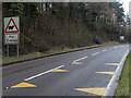
3
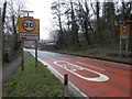
Start of the 30 zone in Blakeney
At the SW edge of the village, the 40mph speed limit on the A48 reduces to 30mph.
Image: © Jaggery
Taken: 3 Feb 2013
0.05 miles
4
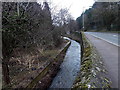
Blackpool Brook, Blakeney
Here flowing along a channel at the edge of the A48.
Image: © Jaggery
Taken: 3 Feb 2013
0.05 miles
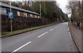
6
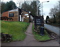
Blakeney Royal British Legion club
Alongside the A48 High Street.
Image: © Jaggery
Taken: 3 Feb 2013
0.07 miles
7
Sheep ahead for 3 miles (possibly) SW of Blakeney
The sign is alongside the A48 at the eastern edge of the Forest of Dean,
where sheep roam freely in mainly locations, such as High Street Bream. http://www.geograph.org.uk/photo/3447020
Image: © Jaggery
Taken: 3 Feb 2013
0.07 miles
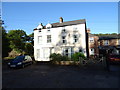
8
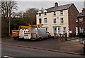
Station Villas, Blakeney
Located alongside the A48, decades ago the villas were near The Forest of Dean Central Railway (or Middle Forest Railway), built in the 1860s to serve the collieries in the heart of the Forest of Dean.
It ran from Awre Junction to Blakeney Walk, serving mines and quarries, and corn mills in Blakeney. The line closed in 1949.
Image: © Jaggery
Taken: 3 Feb 2013
0.08 miles
9
Station Villas, Blakeney
The railway is long gone.
Image: © JThomas
Taken: 17 Oct 2019
0.08 miles
10
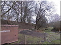
Disused railway embankment, Blakeney
The embankment is on the east side of this http://www.geograph.org.uk/photo/811054 disused viaduct.
Image: © Jaggery
Taken: 3 Feb 2013
0.08 miles