IMAGES TAKEN NEAR TO
Clarks Lane, BLAKENEY, GL15 4BL
Introduction
This page details the photographs taken nearby to Clarks Lane, GL15 4BL by members of the Geograph project.
The Geograph project started in 2005 with the aim of publishing, organising and preserving representative images for every square kilometre of Great Britain, Ireland and the Isle of Man.

There are currently over 7.5m images from over14,400 individuals and you can help contribute to the project by visiting https://www.geograph.org.uk
Image Map
Images are licensed for reuse under creativecommons.org/licenses/by-sa/2.0
Notes
- Clicking on the map will re-center to the selected point.
- The higher the marker number, the further away the image location is from the centre of the postcode.
Image Listing (58 Images Found)
Images are licensed for reuse under creativecommons.org/licenses/by-sa/2.0
Image
Details
Distance
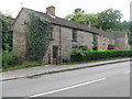
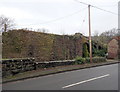
1
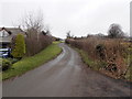
Clark's Lane, Blakeney
Clark's Lane ascends away from this http://www.geograph.org.uk/photo/3323314 disused railway viaduct.
Image: © Jaggery
Taken: 3 Feb 2013
0.06 miles
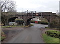
2
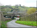
Clark's Lane, Blakeney Hill
The bridge of a dismantled railway indicates the Forest of Dean's industrial past.
Image: © Jonathan Billinger
Taken: 6 Apr 2010
0.08 miles
3
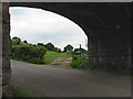
Footpath to Blakeney
From Clarks Lane, beneath the old railway viaduct.
Image: © Pauline E
Taken: 20 May 2008
0.09 miles
4
Western side of a disused railway viaduct, Blakeney
Viewed from New Road past the entrance to Bridge House.
Here's http://www.geograph.org.uk/photo/811054 a view of the eastern side and a few notes.
Image: © Jaggery
Taken: 3 Feb 2013
0.10 miles
5
Houses on New Road
Between the road and the embankment of a disused railway.
Image: © M J Richardson
Taken: 27 Sep 2013
0.10 miles
6
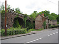
Cottages by the old railway viaduct
Three of the six arches can be seen.
Image: © Pauline E
Taken: 20 May 2008
0.10 miles
7
Entrance to Bridge House
An appropriately named house on New Road, with its access under the bridge of a disused railway.
Image: © M J Richardson
Taken: 27 Sep 2013
0.10 miles
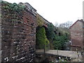
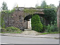
8
Bridge buttress, Blakeney
The stonework and the twin arches supported the eastern end of the railway bridge that formerly crossed New Road here. The rest of the viaduct remains in place. This http://www.geograph.org.uk/photo/3323314 is its eastern side.
Image: © Jaggery
Taken: 3 Feb 2013
0.10 miles
9
Western buttress of a dismantled railway bridge, Blakeney
There was formerly a railway bridge across New Road here. Its course was ENE-WSW over New Road which here is orientated ESE-WNW. The rest of the viaduct remains in place.
Image: © Jaggery
Taken: 3 Feb 2013
0.10 miles
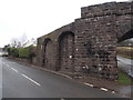
10
North side of a disused railway viaduct, Blakeney
Viewed from Clark's Lane. The section of viaduct over New Road, out of shot on the right, has been removed, but the rest of the viaduct remains in place on the opposite side of the road.
Image: © Jaggery
Taken: 3 Feb 2013
0.10 miles