IMAGES TAKEN NEAR TO
Colsty Meadow, BLAKENEY, GL15 4BG
Introduction
This page details the photographs taken nearby to Colsty Meadow, GL15 4BG by members of the Geograph project.
The Geograph project started in 2005 with the aim of publishing, organising and preserving representative images for every square kilometre of Great Britain, Ireland and the Isle of Man.

There are currently over 7.5m images from over14,400 individuals and you can help contribute to the project by visiting https://www.geograph.org.uk
Image Map
Images are licensed for reuse under creativecommons.org/licenses/by-sa/2.0
Notes
- Clicking on the map will re-center to the selected point.
- The higher the marker number, the further away the image location is from the centre of the postcode.
Image Listing (137 Images Found)
Images are licensed for reuse under creativecommons.org/licenses/by-sa/2.0
Image
Details
Distance
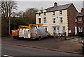
1
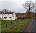
Highfield Road houses, Blakeney
Viewed from the pavement alongside Cinderford Road.
Image: © Jaggery
Taken: 3 Feb 2013
0.04 miles
3
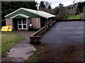
Blakeney Youth Centre
Set back from Cinderford Road Blakeney.
Image: © Jaggery
Taken: 3 Feb 2013
0.06 miles
4
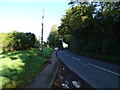
Cinderford Road, Blakeney
Towards Lower Soudley.
Image: © JThomas
Taken: 17 Oct 2019
0.07 miles
5
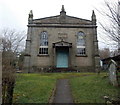
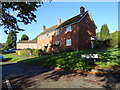
Former Blakeney United Reformed Church
Located on the east side of Cinderford Road. The inscription in stone above the doorway is INDEPENDENT CHAPEL and above it, the year 1849. The Gloucestershire Archives record that in December 1825 a church was formed in Blakeney of the Independent or Congregational Order and was subsequently admitted to the Gloucestershire Association of Independent Churches. In 1848 the church was rebuilt. The new building was opened for worship in 1849. In 1972 Blakeney Congregational Church became part of the United Reformed Church after joining the National Union of Churches. It remained technically a United Reformed Church until closure in September 1987, despite wishing to become an independent congregation following a dispute in 1975.
Image: © Jaggery
Taken: 3 Feb 2013
0.07 miles
6
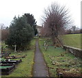
Path through the churchyard of a disused church in Blakeney
The 60 metre long path leads from Cinderford Road to this http://www.geograph.org.uk/photo/3952553 former church.
Image: © Jaggery
Taken: 3 Feb 2013
0.07 miles
7
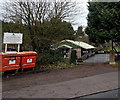
Recycling bank outside the Youth Centre, Blakeney
Located at the edge of Cinderford Road, near the entrance to the Youth Centre. http://www.geograph.org.uk/photo/3952628
Image: © Jaggery
Taken: 3 Feb 2013
0.08 miles
8
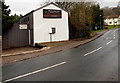
Miles Laughton Joinery in Blakeney
Located in The Workshop, Cinderford Road.
Image: © Jaggery
Taken: 3 Feb 2013
0.09 miles
9
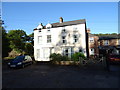
Station Villas, Blakeney
Located alongside the A48, decades ago the villas were near The Forest of Dean Central Railway (or Middle Forest Railway), built in the 1860s to serve the collieries in the heart of the Forest of Dean.
It ran from Awre Junction to Blakeney Walk, serving mines and quarries, and corn mills in Blakeney. The line closed in 1949.
Image: © Jaggery
Taken: 3 Feb 2013
0.10 miles
10
Station Villas, Blakeney
The railway is long gone.
Image: © JThomas
Taken: 17 Oct 2019
0.10 miles