IMAGES TAKEN NEAR TO
Chicknalls, BLAKENEY, GL15 4AQ
Introduction
This page details the photographs taken nearby to Chicknalls, GL15 4AQ by members of the Geograph project.
The Geograph project started in 2005 with the aim of publishing, organising and preserving representative images for every square kilometre of Great Britain, Ireland and the Isle of Man.

There are currently over 7.5m images from over14,400 individuals and you can help contribute to the project by visiting https://www.geograph.org.uk
Image Map
Images are licensed for reuse under creativecommons.org/licenses/by-sa/2.0
Notes
- Clicking on the map will re-center to the selected point.
- The higher the marker number, the further away the image location is from the centre of the postcode.
Image Listing (6 Images Found)
Images are licensed for reuse under creativecommons.org/licenses/by-sa/2.0
Image
Details
Distance
1
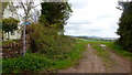
Footpath from Chicknall's Lane
In the distance the distinctive dome of May Hill can be seen.
Image: © Jonathan Billinger
Taken: 5 Apr 2019
0.04 miles
2
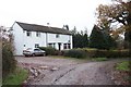
Cottage between Daniel's and Bledisloe Farms.
By the dead-end Chicknall's Lane.
Image: © Jonathan Billinger
Taken: 4 Dec 2006
0.05 miles
3
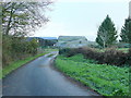
Bledisloe Farm
At the terminus of Chicknalls Lane.
Image: © Jonathan Billinger
Taken: 12 Dec 2011
0.12 miles
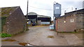
4
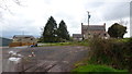
Bledisloe Farm
Farm and house at the end of Chicknall's Lane public road.
Image: © Jonathan Billinger
Taken: 5 Apr 2019
0.13 miles
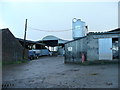
5
Daniel's Farm, 2019
Photo taken over seven years since my last visit to this spot, see Image
The building with the farm sign has been rebuilt.
Image: © Jonathan Billinger
Taken: 5 Apr 2019
0.14 miles
6
Daniel's Farm
A dairy farm on Chicknall's Lane.
Addition 2019; see the same scene in April 2019 - Image
Image: © Jonathan Billinger
Taken: 12 Dec 2011
0.14 miles