IMAGES TAKEN NEAR TO
Newnham Road, BLAKENEY, GL15 4AD
Introduction
This page details the photographs taken nearby to Newnham Road, GL15 4AD by members of the Geograph project.
The Geograph project started in 2005 with the aim of publishing, organising and preserving representative images for every square kilometre of Great Britain, Ireland and the Isle of Man.

There are currently over 7.5m images from over14,400 individuals and you can help contribute to the project by visiting https://www.geograph.org.uk
Image Map
Images are licensed for reuse under creativecommons.org/licenses/by-sa/2.0
Notes
- Clicking on the map will re-center to the selected point.
- The higher the marker number, the further away the image location is from the centre of the postcode.
Image Listing (42 Images Found)
Images are licensed for reuse under creativecommons.org/licenses/by-sa/2.0
Image
Details
Distance
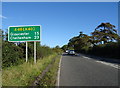
2
A48 heading out of Blakeney
Towards Gloucester.
Image: © JThomas
Taken: 17 Oct 2019
0.07 miles
3
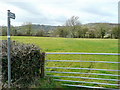
Footpath to Lowfield
View west from the A48 with the hills of the Forest of Dean beyond.
Image: © Jonathan Billinger
Taken: 9 Mar 2011
0.07 miles
6
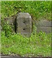
Old Milestone by the A48, north of Blakeney, Awre parish
Carved stone post by the A48, in parish of AWRE (FOREST OF DEAN District), on steep bend 300m North of Blakeney, on grass verge, on East side of road. NC erected by the Chepstow District turnpike trust in the 19th century.
Inscription once read:-
(Chepstow)
(13)
Milestone Society National ID: GL_GLCW15.
Image: © K Walker & R Harvey
Taken: 25 May 2002
0.13 miles
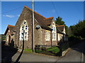
7
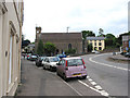
All Saints Church, Blakeney
Built in the 18th century, this is the largest building in the village.
Image: © Pauline E
Taken: 20 May 2008
0.19 miles
8
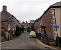
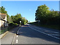
Unsuitable road for wide vehicles, Blakeney
The sign is at the southern end of Church Way, on the corner of All Saints Road.
How wide is not specified.
Image: © Jaggery
Taken: 3 Feb 2013
0.19 miles
9
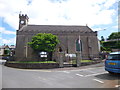
All Saints Church, Blakeney, Gloucester
The church was built in 1813 with an apsidal chancel, nave and south porch. The bell tower only has one bell and clock. In 1890 new windows were installed, with further restoration in 1907. The church is located on the A48, in the centre of the village.
Image: © John C
Taken: 21 Jun 2013
0.20 miles
10
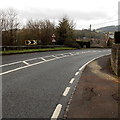
Steep and bendy descent into Blakeney
A sign alongside the A48 behind the camera shows a 11% (1 in 9) gradient, on a sharp bend.
A sign on the left shows that the road narrows ahead.
Image: © Jaggery
Taken: 3 Feb 2013
0.20 miles