IMAGES TAKEN NEAR TO
Midland Road, GLOUCESTER, GL1 4UF
Introduction
This page details the photographs taken nearby to Midland Road, GL1 4UF by members of the Geograph project.
The Geograph project started in 2005 with the aim of publishing, organising and preserving representative images for every square kilometre of Great Britain, Ireland and the Isle of Man.

There are currently over 7.5m images from over14,400 individuals and you can help contribute to the project by visiting https://www.geograph.org.uk
Image Map
Images are licensed for reuse under creativecommons.org/licenses/by-sa/2.0
Notes
- Clicking on the map will re-center to the selected point.
- The higher the marker number, the further away the image location is from the centre of the postcode.
Image Listing (201 Images Found)
Images are licensed for reuse under creativecommons.org/licenses/by-sa/2.0
Image
Details
Distance
1
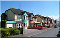
Semi-detached houses, Pembroke Street, Gloucester
The larger houses on this side of Pembroke Street contrast with the houses on the opposite side. http://www.geograph.org.uk/photo/2902317
Image: © Jaggery
Taken: 13 Apr 2012
0.01 miles
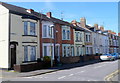
2
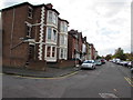
Midland Road houses, Gloucester
Between the Pembroke Street junction (on this side) and the Archibald Street junction.
Image: © Jaggery
Taken: 6 Nov 2016
0.02 miles
3

Ordnance Survey Cut Mark
This OS cut mark can be found on No13 Midland Road. It marks a point 16.502m above mean sea level.
Image: © Adrian Dust
Taken: 9 Jul 2022
0.03 miles
4

Midland Road houses, Gloucester
Between Falkner Street and Goodyere Street.
Image: © Jaggery
Taken: 6 Nov 2016
0.03 miles
5
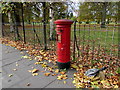
King George VI pillarbox, Trier Way, Gloucester
In November 2016, the pillarbox aperture is sealed by a strip of metal.
Image: © Jaggery
Taken: 6 Nov 2016
0.04 miles
6
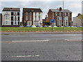
Three-storey houses, Midland Road, Gloucester
Viewed across the A430 Trier Way.
Image: © Jaggery
Taken: 6 Nov 2016
0.05 miles
8
Pembroke Street, Gloucester
Viewed from the corner of All Saints Road.
There are larger, semi-detached, houses on the opposite side of the street. http://www.geograph.org.uk/photo/2902328
Image: © Jaggery
Taken: 13 Apr 2012
0.06 miles
9
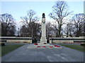
Junction of Trier Way and Park Street, Gloucester
Gloucester War Memorial is at the junction of Trier Way and Park Road.
Image: © Eirian Evans
Taken: 8 Jul 2012
0.06 miles
10
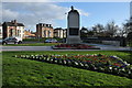
War Memorial, Gloucester
This Gloucester war memorial is situated at the entrance to The Park at the junction of Park Road and Trier Way.
Image: © Philip Halling
Taken: 26 Feb 2011
0.06 miles