IMAGES TAKEN NEAR TO
Slaney Street, GLOUCESTER, GL1 4TQ
Introduction
This page details the photographs taken nearby to Slaney Street, GL1 4TQ by members of the Geograph project.
The Geograph project started in 2005 with the aim of publishing, organising and preserving representative images for every square kilometre of Great Britain, Ireland and the Isle of Man.

There are currently over 7.5m images from over14,400 individuals and you can help contribute to the project by visiting https://www.geograph.org.uk
Image Map
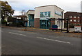
Images are licensed for reuse under creativecommons.org/licenses/by-sa/2.0
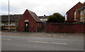
Notes
- Clicking on the map will re-center to the selected point.
- The higher the marker number, the further away the image location is from the centre of the postcode.
Image Listing (72 Images Found)
Images are licensed for reuse under creativecommons.org/licenses/by-sa/2.0
Image
Details
Distance
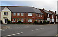
1
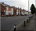
Tredworth Road houses, Gloucester
The corner of Conduit Street http://www.geograph.org.uk/photo/5184834 is on the left.
Image: © Jaggery
Taken: 6 Nov 2016
0.07 miles
2
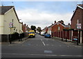
Conduit Street, Tredworth, Gloucester
Looking north across Tredworth Road.
Image: © Jaggery
Taken: 6 Nov 2016
0.09 miles
3
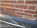
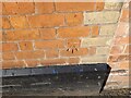
Ordnance Survey Cut Mark
This OS cut mark can be found on the Victory Hotel. It marks a point 20.544m above mean sea level.
Image: © Adrian Dust
Taken: 9 Jul 2022
0.10 miles
4
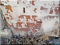
Ordnance Survey Cut Mark
This OS cut mark can be found on No65 Tredworth Road. It marks a point 20.635m above mean sea level.
Image: © Adrian Dust
Taken: 9 Jul 2022
0.11 miles
5
Ordnance Survey Cut Mark
This OS cut mark can be found on No102A High Street. It marks a point 17.825m above mean sea level.
Image: © Adrian Dust
Taken: 9 Jul 2022
0.12 miles
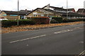
6
Corner of Furlong Road and Tredworth Road, Gloucester
Viewed across Tredworth Road near the corner of Stroud Road.
Image: © Jaggery
Taken: 6 Nov 2016
0.12 miles
7
Rosebank Surgery and Lloyds Pharmacy, Gloucester
Viewed across the B4072 Stroud Road.
Image: © Jaggery
Taken: 6 Nov 2016
0.12 miles
8
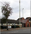
Stroud Road telecoms mast and cabinets, Gloucester
Located outside Rosebank Surgery. An electricity substation http://www.geograph.org.uk/photo/5185608 is on the right.
Image: © Jaggery
Taken: 6 Nov 2016
0.13 miles
9
Stroud Road electricity substation, Gloucester
The Western Power Distribution electricity substation identifier is STROUD RD S/S 4550.
A warning on the substation shows the presence of SF6 (sulphur hexafluoride, an insulating gas used in high voltage systems).
Image: © Jaggery
Taken: 6 Nov 2016
0.13 miles
10
Stroud Road Pharmacy, Gloucester
At 153A Stroud Road, near Rosebank medical surgery.
Image: © Jaggery
Taken: 6 Nov 2016
0.13 miles