IMAGES TAKEN NEAR TO
Wellesley Street, GLOUCESTER, GL1 4QP
Introduction
This page details the photographs taken nearby to Wellesley Street, GL1 4QP by members of the Geograph project.
The Geograph project started in 2005 with the aim of publishing, organising and preserving representative images for every square kilometre of Great Britain, Ireland and the Isle of Man.

There are currently over 7.5m images from over14,400 individuals and you can help contribute to the project by visiting https://www.geograph.org.uk
Image Map
Images are licensed for reuse under creativecommons.org/licenses/by-sa/2.0
Notes
- Clicking on the map will re-center to the selected point.
- The higher the marker number, the further away the image location is from the centre of the postcode.
Image Listing (33 Images Found)
Images are licensed for reuse under creativecommons.org/licenses/by-sa/2.0
Image
Details
Distance
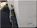
1
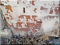
Ordnance Survey Cut Mark
This OS cut mark can be found on No65 Tredworth Road. It marks a point 20.635m above mean sea level.
Image: © Adrian Dust
Taken: 9 Jul 2022
0.06 miles
2
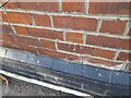
Ordnance Survey Cut Mark
This OS cut mark can be found on the Victory Hotel. It marks a point 20.544m above mean sea level.
Image: © Adrian Dust
Taken: 9 Jul 2022
0.13 miles
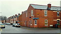
3
Tarrington Road, Tredworth
A dead-end section of this street.
Image: © Jonathan Billinger
Taken: 24 Dec 2012
0.15 miles
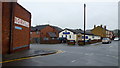
4
Ex-corner shop, Tredworth
On the corner of Hatherley and Tarrington Roads the owners have filled in the diagonal door but kept the vestiges of the sign.
Image: © Jonathan Billinger
Taken: 24 Dec 2012
0.16 miles
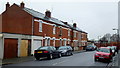
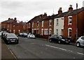
5
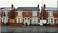
Older semi's, Tredworth Road
Early 20th century housing in Gloucester.
Image: © Jonathan Billinger
Taken: 24 Dec 2012
0.17 miles
6
Church of God, Hatherley Road, Gloucester
A Seventh Day place of worship.
http://www.cog7thday.org.uk/StandardPage.aspx?Key=OurBranches&Id=Gloucester
The Norville sign is on the old premises of a spectacle manufacturer in the city.
http://www.norville.co.uk/
Image: © Jonathan Billinger
Taken: 24 Dec 2012
0.18 miles
7
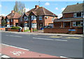
Stroud Road houses, Gloucester
Viewed from the corner of Tweenbrook Avenue. http://www.geograph.org.uk/photo/2905450
Image: © Jaggery
Taken: 13 Apr 2012
0.18 miles
8
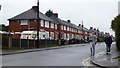
Off to the pub?
Two men on their way along Hartland Road on Christmas Eve, 2012.
Image: © Jonathan Billinger
Taken: 24 Dec 2012
0.19 miles
9
Ordnance Survey Cut Mark
This OS cut mark can be found on No8 Goodwin Court. It marks a point 19.030m above mean sea level.
Image: © Adrian Dust
Taken: 9 Jul 2022
0.19 miles
10
Sydenham Terrace, Gloucester
From Stanley Terrace along Sydenham Terrace towards Calton Road.
Image: © Jaggery
Taken: 6 Nov 2016
0.19 miles