IMAGES TAKEN NEAR TO
Barton Street, GLOUCESTER, GL1 4EZ
Introduction
This page details the photographs taken nearby to Barton Street, GL1 4EZ by members of the Geograph project.
The Geograph project started in 2005 with the aim of publishing, organising and preserving representative images for every square kilometre of Great Britain, Ireland and the Isle of Man.

There are currently over 7.5m images from over14,400 individuals and you can help contribute to the project by visiting https://www.geograph.org.uk
Image Map
Images are licensed for reuse under creativecommons.org/licenses/by-sa/2.0
Notes
- Clicking on the map will re-center to the selected point.
- The higher the marker number, the further away the image location is from the centre of the postcode.
Image Listing (137 Images Found)
Images are licensed for reuse under creativecommons.org/licenses/by-sa/2.0
Image
Details
Distance
1
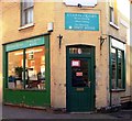
Custom Frames, Barton Street, Gloucester
Image: © nick macneill
Taken: 12 Oct 2012
0.01 miles
2
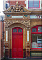
Detail of former pub, Barton Street, Gloucester
Example of the sumptuous detail to this building: Image
Image: © Stephen Richards
Taken: 18 May 2015
0.03 miles
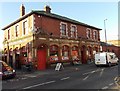
3
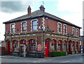
Former pub, Barton Street, Gloucester
An exceedingly lavish Victorian affair, built c1900 probably by Knight & Chatters. The ground floor is slathered in colourful ceramic tiles (Image]). Grade II listed.
The former Vauxhall Inn was a Polish supermarket at the time of the photo.
Image: © Stephen Richards
Taken: 18 May 2015
0.03 miles
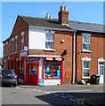
4
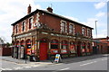
The Vauxhall Inn, former public House
The Vauxhall Inn a former public house in Barton Street, Gloucester. The current owners are using it as a small supermarket.
Image: © Colin Manton
Taken: 14 Jun 2011
0.03 miles
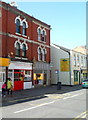
5
Vauxhall Supermarket, Gloucester
The supermarket is in the former Vauxhall Inn on the corner of Barton Street and Vauxhall Road.
Image: © Jaggery
Taken: 22 Nov 2013
0.04 miles
6
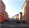
Stratton Road, Gloucester
Viewed from the Barton Street end.
Image: © Jaggery
Taken: 22 Nov 2013
0.05 miles
7
Old-style corner shop, Gloucester
W.N.Gordon and Son, off licence and general store, on the corner of Millbrook Street and Magdala Road.
Image: © Jaggery
Taken: 13 Apr 2012
0.06 miles
9
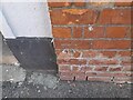
Ordnance Survey Cut Mark
This OS cut mark can be found on the old Bingo Hall on Blenheim Road. It marks a point 18.242m above mean sea level.
Image: © Adrian Dust
Taken: 9 Jul 2022
0.06 miles
10
Kurdistan Restaurant, Gloucester
The restaurant is the premises with the red door, at 156 Barton Street.
Image: © Jaggery
Taken: 13 Apr 2012
0.07 miles