IMAGES TAKEN NEAR TO
Ince Castle Way, GLOUCESTER, GL1 4DT
Introduction
This page details the photographs taken nearby to Ince Castle Way, GL1 4DT by members of the Geograph project.
The Geograph project started in 2005 with the aim of publishing, organising and preserving representative images for every square kilometre of Great Britain, Ireland and the Isle of Man.

There are currently over 7.5m images from over14,400 individuals and you can help contribute to the project by visiting https://www.geograph.org.uk
Image Map
Images are licensed for reuse under creativecommons.org/licenses/by-sa/2.0
Notes
- Clicking on the map will re-center to the selected point.
- The higher the marker number, the further away the image location is from the centre of the postcode.
Image Listing (52 Images Found)
Images are licensed for reuse under creativecommons.org/licenses/by-sa/2.0
Image
Details
Distance
1
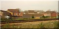
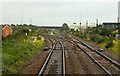
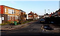
Houses in Tredworth, Gloucester
Houses on Bishop's Castle Way seen from the main line just north-east of the Gloucester Yard junction shown in Image
Image: © Derek Harper
Taken: 10 Apr 2015
0.02 miles
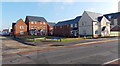
2
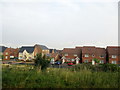
Gloucester Houses in Diamond Jubilee Close
Image: © Roy Hughes
Taken: 21 Jul 2018
0.04 miles
3
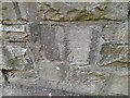
Ordnance Survey Cut Mark
This OS cut mark can be found on the NE buttress of the railway bridge. It marks a point 23.656m above mean sea level.
Image: © Adrian Dust
Taken: 9 Jul 2022
0.05 miles
5
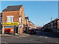
Hatfield Road, Gloucester
Viewed across Barton Street looking towards India Road. The corner shop is Norats Newsagents.
Image: © Jaggery
Taken: 22 Nov 2013
0.07 miles
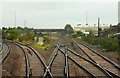
7
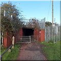
Railway underpass in Gloucester
West of the corner of Malmesbury Road and Savernake Road, a footpath passes under railway lines.
Image: © Jaggery
Taken: 22 Nov 2013
0.07 miles
8
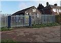
Gloucestershire ACF Malmesbury Road Platoon compound, Gloucester
The Army Cadet Force site is on the corner of Malmesbury Road and Savernake Road.
Image: © Jaggery
Taken: 22 Nov 2013
0.11 miles
9
Savernake Road, Gloucester
Looking towards Malmesbury Road from Chequers Road.
Image: © Jaggery
Taken: 22 Nov 2013
0.11 miles
10
East side of Diamond Jubilee Close, Gloucester
A Barratt Homes development viewed across Barton Street from the corner of Massey Road.
Image: © Jaggery
Taken: 22 Nov 2013
0.12 miles