IMAGES TAKEN NEAR TO
Millbrook Street, GLOUCESTER, GL1 4BH
Introduction
This page details the photographs taken nearby to Millbrook Street, GL1 4BH by members of the Geograph project.
The Geograph project started in 2005 with the aim of publishing, organising and preserving representative images for every square kilometre of Great Britain, Ireland and the Isle of Man.

There are currently over 7.5m images from over14,400 individuals and you can help contribute to the project by visiting https://www.geograph.org.uk
Image Map
Images are licensed for reuse under creativecommons.org/licenses/by-sa/2.0
Notes
- Clicking on the map will re-center to the selected point.
- The higher the marker number, the further away the image location is from the centre of the postcode.
Image Listing (151 Images Found)
Images are licensed for reuse under creativecommons.org/licenses/by-sa/2.0
Image
Details
Distance
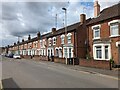
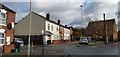
1
Magdala Road
Victorian terraced housing north of Barton Street.
Image: © Ian Capper
Taken: 16 Mar 2019
0.04 miles
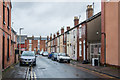
2
East along Napier Street, Gloucester
Towards Raglan Street from the corner of Sinope Street.
Image: © Jaggery
Taken: 6 Nov 2016
0.05 miles
3
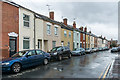
Millbrook Street
Victorian terraced housing north of Barton Street.
Image: © Ian Capper
Taken: 16 Mar 2019
0.06 miles
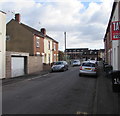
4
Lobb Court, Millbrook Street, Gloucester
Image: © Chris Morgan
Taken: 2 Nov 2019
0.07 miles
5
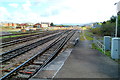
A view from the SE edge of Gloucester railway station
The camera is at the edge of platform 1, at the point beyond which passengers must not go.
Ahead on the right is a track through grass for the use of railway staff.
Image: © Jaggery
Taken: 2 Apr 2012
0.07 miles
6
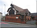
Ukrainian Catholic Church
In Derby Road, Gloucester.
Image: © David Stowell
Taken: 18 Sep 2005
0.08 miles
7
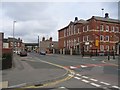
Derby Road, Gloucester
Looking north with the old technical school on the right. The bridge in the distance carries the new eastern spine road whilst beyond can be seen the raised barriers of Horton Road (a.k.a.Tramway) Crossing.
Image: © David Stowell
Taken: 18 Sep 2005
0.08 miles
8
Great Western Court
Gloucestershire County Council's residential bed based reablement unit
Image: © Chris Morgan
Taken: 2 Nov 2019
0.08 miles
9

Gloucester Eastgate station, north end 1964
View NE from the Down platform of the ex-Midland station to the junction with the ex-GWR main line and Horton Road running-shed. As evidenced by the swarm of Spotters - with seats and greenery to boot, this could not have been a more idyllic spot at which to enjoy the hobby. You could see all the comings and goings at the GW Shed and note all the Great Western trains on their main route to and through their Central station - off to the left. These came from the right from Cheltenham, Birmingham etc. and from the London direction via Swindon; thus Cheltenham - Swindon - Paddington trains were seen twice. Eastgate station served the ex-Midland trains from Birmingham and the North via Cheltenham and on towards Bristol, Bath etc. behind the camera. Unfortunately, Eastgate station and the whole ex-Midland Tuffley loop was closed from 2/12/75 and all concentrated at a rebuilt Central station, trains from/to the Bristol direction then having also to reverse there. The whole area here was given over to Roads and Supermarkets, making this scene quite unrecognisable.
Image: © Ben Brooksbank
Taken: 20 Jun 1964
0.09 miles