IMAGES TAKEN NEAR TO
Napier Street, GLOUCESTER, GL1 4AS
Introduction
This page details the photographs taken nearby to Napier Street, GL1 4AS by members of the Geograph project.
The Geograph project started in 2005 with the aim of publishing, organising and preserving representative images for every square kilometre of Great Britain, Ireland and the Isle of Man.

There are currently over 7.5m images from over14,400 individuals and you can help contribute to the project by visiting https://www.geograph.org.uk
Image Map
Images are licensed for reuse under creativecommons.org/licenses/by-sa/2.0
Notes
- Clicking on the map will re-center to the selected point.
- The higher the marker number, the further away the image location is from the centre of the postcode.
Image Listing (280 Images Found)
Images are licensed for reuse under creativecommons.org/licenses/by-sa/2.0
Image
Details
Distance
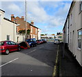
1
Napier Street, Gloucester
From Widden Street.
Image: © Jaggery
Taken: 6 Nov 2016
0.02 miles
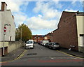
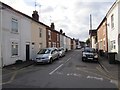
2
West along Napier Street, Gloucester
From the corner of Sinope Street.
Image: © Jaggery
Taken: 6 Nov 2016
0.02 miles
3
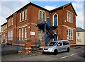
Al-Ashraf Secondary School for Girls, Gloucester
The Sinope Street side of the Islamic school on the corner of Napier Street.
Image: © Jaggery
Taken: 6 Nov 2016
0.03 miles
4
Northern end of Sinope Street, Gloucester
From Napier Street towards Widden Primary School and Bartongate Children's Centre.
Image: © Jaggery
Taken: 6 Nov 2016
0.03 miles
5
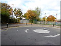
Mini-roundabout at the northern end of Sinope Street, Gloucester
The fencing is the perimeter of Widden Primary School and Bartongate Children's Centre.
Image: © Jaggery
Taken: 6 Nov 2016
0.03 miles
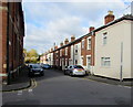
6
Sinope Street, Gloucester
Viewed from near this mini-roundabout http://www.geograph.org.uk/photo/5237342 looking towards the Napier Street crossroads.
Image: © Jaggery
Taken: 6 Nov 2016
0.03 miles
7
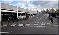
Upper level car park access ramp, Gloucester
The two-level car park is opposite an Asda superstore.
Old maps show that this location used to be part of Gloucester Eastgate railway station which closed in 1975.
Image: © Jaggery
Taken: 6 Nov 2016
0.04 miles
8
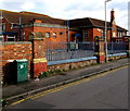
Widden Street school buildings, Gloucester
On the south side of Al-Ashraf Secondary School for Girls. On the right, a stone http://www.geograph.org.uk/photo/5237210 dated 1877 in the wall below the chimney records that this was the first school built by the Gloucester School Board.
Image: © Jaggery
Taken: 6 Nov 2016
0.04 miles
9

Foundation stone commemorating the first school built by the Gloucester School Board
The stone dated October 15th 1877 is on the right here. http://www.geograph.org.uk/photo/5237207
Image: © Jaggery
Taken: 6 Nov 2016
0.04 miles
10
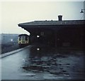
Gloucester Eastgate Station
The former Gloucester Eastgate Station, photographed before closure some time in the 1970s on my first instamatic camera!
Image: © Bill Blair
Taken: Unknown
0.04 miles