IMAGES TAKEN NEAR TO
Charles Street, GLOUCESTER, GL1 4AG
Introduction
This page details the photographs taken nearby to Charles Street, GL1 4AG by members of the Geograph project.
The Geograph project started in 2005 with the aim of publishing, organising and preserving representative images for every square kilometre of Great Britain, Ireland and the Isle of Man.

There are currently over 7.5m images from over14,400 individuals and you can help contribute to the project by visiting https://www.geograph.org.uk
Image Map
Images are licensed for reuse under creativecommons.org/licenses/by-sa/2.0
Notes
- Clicking on the map will re-center to the selected point.
- The higher the marker number, the further away the image location is from the centre of the postcode.
Image Listing (294 Images Found)
Images are licensed for reuse under creativecommons.org/licenses/by-sa/2.0
Image
Details
Distance
1
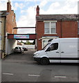
Ghousia Masjid entrance, Gloucester
The masjid (mosque) entrance is on the east side of Charles Street.
Image: © Jaggery
Taken: 6 Nov 2016
0.00 miles
2
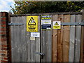
Helipebs electricity substation, Gloucester
The Western Power Distribution electricity substation is on the corner of Charles Street and Widden Street. Its identifier is HELIPEBS S/S 5047. The unusual name is mostly likely a reference to the Gloucester business now located in Sisson Road in the city. Helipebs began in 1834 as Kell, Meats and Co producing agricultural implements and machines. Helipebs is currently one of the world's leading manufacturers of fluid power technology.
A Caution notice shows the presence of SF6 (sulphur hexafluoride, an insulating gas used in high voltage systems).
Image: © Jaggery
Taken: 6 Nov 2016
0.02 miles
3
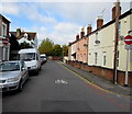
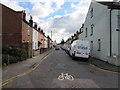
Widden Street towards Charles Street, Gloucester
From the corner of Napier Street. No entry for vehicles except cycles.
Image: © Jaggery
Taken: 6 Nov 2016
0.03 miles
4
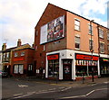
Diamond on a Gloucester corner
Diamond Hair Products Ltd is on the corner of Barton Street and Charles Street.
Image: © Jaggery
Taken: 6 Nov 2016
0.03 miles
5
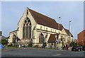
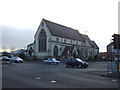
Former All Saints Church, Gloucester
Built 1875 by Sir George Gilbert Scott, in what the Listing describes as 'Middle Pointed style'. Listed Grade II. It became the Anglo-Asian Cultural Centre, a Chinese-based organisation – in 2000.
One feature missing from this view is the former Midland Railway main line between Bristol and Birmingham which crossed Barton Street by a level crossing with an unusual signal box on a gantry above the tracks, visible in this view http://www.disused-stations.org.uk/g/gloucester_eastgate/index23.shtml . The section of the line through the City was closed in 1975 because of the disruption caused by this and 4 other level crossings, with all trains being re-routed to use the present Gloucester station.
Image: © Alan Murray-Rust
Taken: 15 Apr 2019
0.03 miles
6
Widden Street, Gloucester
From the corner of Charles Street.
Image: © Jaggery
Taken: 6 Nov 2016
0.03 miles
7
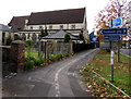
Turn left here for Tredworth, Gloucester
One of four cycle route and footpath direction signs alongside Bruton Way.
Image: © Jaggery
Taken: 6 Nov 2016
0.03 miles
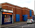
8
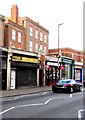
Jayzee Traders, Barton Street, Gloucester
Close and shuttered on a Sunday, Jayzee Traders (computers, electrical appliances and fancy goods)
is at 116 Barton Street. Jayzee also provides a Western Union money transfer service.
Image: © Jaggery
Taken: 6 Nov 2016
0.04 miles
10
Romania shop and off licence, Barton Street, Gloucester
The shop at 110 Barton Street specialises in Romanian food.
Image: © Jaggery
Taken: 6 Nov 2016
0.04 miles