IMAGES TAKEN NEAR TO
Oak Way, CINDERFORD, GL14 3NE
Introduction
This page details the photographs taken nearby to Oak Way, GL14 3NE by members of the Geograph project.
The Geograph project started in 2005 with the aim of publishing, organising and preserving representative images for every square kilometre of Great Britain, Ireland and the Isle of Man.

There are currently over 7.5m images from over14,400 individuals and you can help contribute to the project by visiting https://www.geograph.org.uk
Image Map
Images are licensed for reuse under creativecommons.org/licenses/by-sa/2.0
Notes
- Clicking on the map will re-center to the selected point.
- The higher the marker number, the further away the image location is from the centre of the postcode.
Image Listing (156 Images Found)
Images are licensed for reuse under creativecommons.org/licenses/by-sa/2.0
Image
Details
Distance
1
Phone box by Littledean Stores
Independent village retailer on the A4151.
Image: © Pauline E
Taken: 27 Mar 2008
0.05 miles
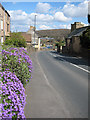
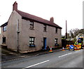
2
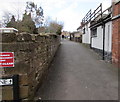
Folders Lane, Littledean
On the north side of Broad Street.
Image: © Jaggery
Taken: 1 Mar 2015
0.05 miles
3
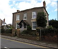
The Manse, Littledean
Viewed across Broad Street. The Manse was formerly the residence of the minister at this http://www.geograph.org.uk/photo/4378023 nearby church.
Image: © Jaggery
Taken: 1 Mar 2015
0.05 miles
4
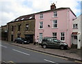
Pink house in Littledean
On the north side of Broad Street, opposite the War Memorial. http://www.geograph.org.uk/photo/4497700
The entrance to Oakdale Cottage is on the right.
Image: © Jaggery
Taken: 1 Mar 2015
0.06 miles
5
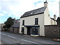
The Bell House, Littledean
The Church Street house has a shop-style front.
Image: © Jaggery
Taken: 1 Mar 2015
0.06 miles
6

Signpost and BT grey phonebox in Littledean
On the corner of Broad Street and Folders Lane.
Image: © Jaggery
Taken: 1 Mar 2015
0.06 miles
7
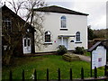
Shared church building in Littledean
The church is set back 15 metres from the south side of Broad Street.
The Salvation Army name is on the left side of the doorway.
United Reformed Church is on the right side.
Image: © Jaggery
Taken: 1 Mar 2015
0.06 miles
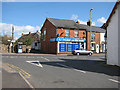
8
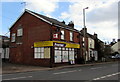
Littledean Stores, Littledean
In early March 2015, the shop on the corner of Broad Street and Folders Lane is much changed since this http://www.geograph.org.uk/photo/741234 view taken in March 2008. It is now a Premier Store with post office facilities. The post office was previously in a nearby shop, now derelict.
Image: © Jaggery
Taken: 1 Mar 2015
0.06 miles
9
Church Road, Littledean
On its way to join the A48 and on to Gloucester. The tower of St. Ethelbert's, with its missing spire, can be seen on the right.
Image: © Pauline E
Taken: 27 Mar 2008
0.06 miles
10
Tremaine, Littledean
Many of the houses on this side of Church Street have a name but no number.
Image: © Jaggery
Taken: 1 Mar 2015
0.06 miles