IMAGES TAKEN NEAR TO
Wellingtons Grove, CINDERFORD, GL14 3GB
Introduction
This page details the photographs taken nearby to Wellingtons Grove, GL14 3GB by members of the Geograph project.
The Geograph project started in 2005 with the aim of publishing, organising and preserving representative images for every square kilometre of Great Britain, Ireland and the Isle of Man.

There are currently over 7.5m images from over14,400 individuals and you can help contribute to the project by visiting https://www.geograph.org.uk
Image Map (Loading...)


Getting Data...Please wait
Leaflet Map data © OpenStreetMap
Images are licensed for reuse under creativecommons.org/licenses/by-sa/2.0
Notes
- Clicking on the map will re-center to the selected point.
- The higher the marker number, the further away the image location is from the centre of the postcode.
Image Listing (27 Images Found)
Images are licensed for reuse under creativecommons.org/licenses/by-sa/2.0
Image
Details
Distance
1

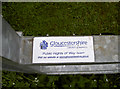
Boundary Stone, Ruspidge, Forest of Dean
In the corner of Playing Fields in Sneyd Wood Road, marking the boundary of the Royal Forest that runs N/S in this region.
An original 1832 stone found in a garden totally buried and re-instated in the 21ˢᵗC in a public place.
Inscription: D. F. / 1832 / Nᴼ. 216
Milestone Society National ID: GL_DFRUSU216em
Image: © Mr Red
Taken: 18 Apr 2025
0.06 miles
2
Footpath to Buckshaft, Ruspidge, Forest of Dean
This footpath, opposite the old Ruspidge sub-Post Office (now Ruspidge Shop), leads along a 200 metre footpath to Buckshaft. Close to the left of the footpath is the Saint White's School.
Image: © Eric Soons
Taken: 9 Nov 2008
0.07 miles
3
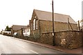
Saint White's School, Ruspidge, Forest of Dean
Saint White's School is located on the Southern side of Saint White's Road and extends round the corner (far distance of the photo) into Buckshaft where it continues - thus forming an L-shape. The school has spread to the other side of the road in Buckshaft. This forces a very careful transfer of pupils across Buckshaft when they move from one part of the school to the other.
Image: © Eric Soons
Taken: 9 Nov 2008
0.10 miles
4
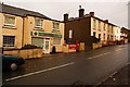
Old Ruspidge sub-post office, Forest of Dean
Until very recently this was the old sub-post office for Ruspidge, although officially on the wrong side of Saint White's road to be Ruspidge. Since the recent (October, 2008) closure of the Post Office side of the business the name and business has changed to 'Ruspidge Shop.'
Image: © Eric Soons
Taken: 9 Nov 2008
0.12 miles
5
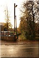
Footpath gate near the trig point
A new-looking galvanised gate marks the footpath from the track to the farm nicely. A label is attached to the rail of the gate, informing of the proprietors: Image Just a few paces away is the trig pillar - see Image
Image: © Neil Owen
Taken: 29 Jul 2011
0.13 miles
6
Keeping the way ahead clear
Patently someone cares for and upholds the footpaths and tracks in Gloucestershire. See Image] for a contextual view
Image: © Neil Owen
Taken: 29 Jul 2011
0.13 miles
7
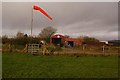
Windsock and Saint White's Farm, Ruspidge, Forest of Dean
Just off Saint White's road at the brow of the hill opposite the Mount Pleasant public house is a gravelled road running due south that leads to the field with the windsock that is a temporary helicopter landing field. The buildings are some of the barns associated with Saint Whites Farm which can just be seen in the photo.
Image: © Eric Soons
Taken: 10 Nov 2008
0.14 miles
8
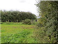
Hedge-side path near Cinderford
Looking westward to modern metal kissing-gate.
Image: © Peter Wood
Taken: 15 Oct 2016
0.15 miles
9
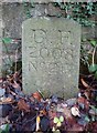
Modern Boundary Stone, Buckshaft Road
On the verge/berm against a wall, adjacent to 2 telephone poles, opposite house 1a.
It marks the boundary of the "Forest of Dean", in the parish of Ruspidge and Soudley.
Inscription: D. F. / 2008 / Nᴼ. 217
Milestone Society National ID: GL_DFRUSU217em
Image: © Mr Red
Taken: 6 Dec 2022
0.15 miles
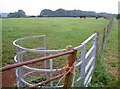
10
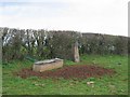
Triangulation pillar and trough, St White's
A farmed corner of the Forest.
Image: © Richard Webb
Taken: 3 Apr 2004
0.15 miles