IMAGES TAKEN NEAR TO
St. Whites Road, CINDERFORD, GL14 3DQ
Introduction
This page details the photographs taken nearby to St. Whites Road, GL14 3DQ by members of the Geograph project.
The Geograph project started in 2005 with the aim of publishing, organising and preserving representative images for every square kilometre of Great Britain, Ireland and the Isle of Man.

There are currently over 7.5m images from over14,400 individuals and you can help contribute to the project by visiting https://www.geograph.org.uk
Image Map (Loading...)


Getting Data...Please wait
Leaflet Map data © OpenStreetMap
Images are licensed for reuse under creativecommons.org/licenses/by-sa/2.0
Notes
- Clicking on the map will re-center to the selected point.
- The higher the marker number, the further away the image location is from the centre of the postcode.
Image Listing (31 Images Found)
Images are licensed for reuse under creativecommons.org/licenses/by-sa/2.0
Image
Details
Distance
1
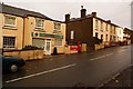
Old Ruspidge sub-post office, Forest of Dean
Until very recently this was the old sub-post office for Ruspidge, although officially on the wrong side of Saint White's road to be Ruspidge. Since the recent (October, 2008) closure of the Post Office side of the business the name and business has changed to 'Ruspidge Shop.'
Image: © Eric Soons
Taken: 9 Nov 2008
0.04 miles
2
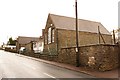
Saint White's School, Ruspidge, Forest of Dean
Saint White's School is located on the Southern side of Saint White's Road and extends round the corner (far distance of the photo) into Buckshaft where it continues - thus forming an L-shape. The school has spread to the other side of the road in Buckshaft. This forces a very careful transfer of pupils across Buckshaft when they move from one part of the school to the other.
Image: © Eric Soons
Taken: 9 Nov 2008
0.06 miles
4
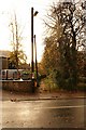
Footpath to Buckshaft, Ruspidge, Forest of Dean
This footpath, opposite the old Ruspidge sub-Post Office (now Ruspidge Shop), leads along a 200 metre footpath to Buckshaft. Close to the left of the footpath is the Saint White's School.
Image: © Eric Soons
Taken: 9 Nov 2008
0.11 miles
5
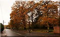
Stockwell Green, Cinderford, Forest of Dean
In this photo we are looking down Saint White's road with the oaks and rock borders of the patch of common land, Stockwell Green on the left (Northern) side of the road.
Image: © Eric Soons
Taken: 11 Nov 2008
0.14 miles
6
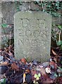
Modern Boundary Stone, Buckshaft Road
On the verge/berm against a wall, adjacent to 2 telephone poles, opposite house 1a.
It marks the boundary of the "Forest of Dean", in the parish of Ruspidge and Soudley.
Inscription: D. F. / 2008 / Nᴼ. 217
Milestone Society National ID: GL_DFRUSU217em
Image: © Mr Red
Taken: 6 Dec 2022
0.14 miles
7
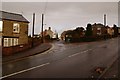
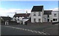
Church road junction, Cinderford, Forest of Dean
The Southern boundary of Cinderford is marked by Saint White's Road - this marks the start of Church road. Church road runs along the length of the Eastern ridge of North/South high ground upon which Cinderford is built. The Northern end of Church road ends at 'The Triangle' which is the centre of the town.
Image: © Eric Soons
Taken: 9 Nov 2008
0.17 miles
8
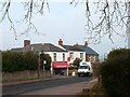
Bristol House Stores
Neighbourhood shop in Church Road.
Image: © Des Blenkinsopp
Taken: 9 Feb 2012
0.17 miles
9
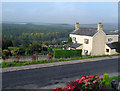
View from Church Road, Cinderford
Church Road is terraced along the side of a valley, with many houses having this fine westerly view over the Forest of Dean.
Image: © Des Blenkinsopp
Taken: 9 Oct 2010
0.17 miles
10
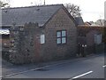
Old Tollhouse, 26 St White's Road
In the modern parish of Ruspidge and Soudley. Within the boundaries of the "Forest of Dean", and still showing a "TP" on the 1873 map. This building served the Forest of Dean Turnpike Trust.
Milestone Society National ID: GL.CIN01
Image: © Mr Red
Taken: 18 Nov 2022
0.17 miles