IMAGES TAKEN NEAR TO
Tramway Road, CINDERFORD, GL14 2UG
Introduction
This page details the photographs taken nearby to Tramway Road, GL14 2UG by members of the Geograph project.
The Geograph project started in 2005 with the aim of publishing, organising and preserving representative images for every square kilometre of Great Britain, Ireland and the Isle of Man.

There are currently over 7.5m images from over14,400 individuals and you can help contribute to the project by visiting https://www.geograph.org.uk
Image Map (Loading...)


Getting Data...Please wait
Leaflet Map data © OpenStreetMap
Images are licensed for reuse under creativecommons.org/licenses/by-sa/2.0
Notes
- Clicking on the map will re-center to the selected point.
- The higher the marker number, the further away the image location is from the centre of the postcode.
Image Listing (54 Images Found)
Images are licensed for reuse under creativecommons.org/licenses/by-sa/2.0
Image
Details
Distance
1
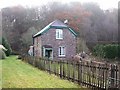
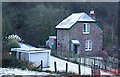
Gatekeepers cottage, Soudley, Forest of Dean
At one time this cottage housed the keeper of the level crossing for the single track railway line that went along what is now a patch of grass beside the cottage. The gatekeeper was also responsible for the receipt and despatch of trains through the tunnel behind the cottage that was driven through Bradley Hill. Each engine driver had to take a token from the gatekeeper and surrender it at the other end of the tunnel - so that it was impossible for there to be two trains in the tunnel at any one time.
Image: © Eric Soons
Taken: 18 Nov 2008
0.05 miles
2
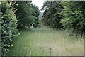
The route of the Forest of Dean Railway at Soudley
Taken looking towards Ruspidge and Cinderford from Tramway Road in Soudley. Behind me is a former level crossing, the north portal of Bradley Hill tunnel and the old crossing keeper's cottage featured in Des Blenkinsop's Image Beyond the trees is a short cutting and the site of Soudley Halt, now a pub car park.
Image: © John Winder
Taken: 4 Jun 2020
0.05 miles
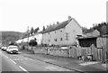
3
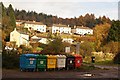
Soudley, Forest of Dean
Soudley as seen from the Soudley Village Hall car park with a colourful chain or recycling bins in the foreground.
Image: © Eric Soons
Taken: 15 Nov 2008
0.05 miles
4
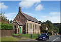
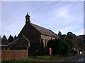
St Michael's, Upper Soudley, (recently closed)
St Michael and All Angels Church was built in 1909 and was used as a place of worship until 30 April 2017, another casualty of dwindling congregations and rising costs.
https://www.cinderford-churches.org.uk/our-churches/st-michaels-soudley
Image: © Des Blenkinsopp
Taken: 24 Sep 2019
0.06 miles
5

Level Crossing Keeper's Cottage - Soudley
In days gone by when there was heavy industry, coal and stone from the Forest of Dean, there was a single track rail road with a level crossing at this point. The Level Crossing Keeper kept a Key or Token for the passing train. Behind the cottage is the entrance to the old Bradley Hill Tunnel which led down, eventually, to the River Severn.
Image: © Eric Soons
Taken: 30 Jun 2008
0.06 miles
6
Gatekeepers cottage, Soudley, Forest of Dean
The Gatekeeper, in times gone by, looked after a set of level crossing gates and was keeper of a Token that was passed by engine drivers using the single track railway through the tunnel behind the house. The frosty long 'lawn' between the cottage and the garage is the remnant of the original railway track that led, eventually, down to the River Severn.
Image: © Eric Soons
Taken: 5 Jan 2009
0.06 miles
7
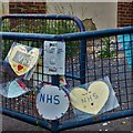
Lockdown NHS tributes, Soudley
Schoolchildren's NHS tributes attached to a fence outside Soudley Primary School.
Image: © John Winder
Taken: 4 Jun 2020
0.07 miles
8
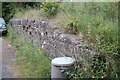
Old railway loading dock, Soudley
A short siding, long enough for three wagons, once ran alongside this dock, which was mostly used for loading stone.
Image: © John Winder
Taken: 4 Jun 2020
0.08 miles
10
St. Michael and all angels, Soudley, Forest of Dean
The church of Saint Michael and all angels in Church road, Soudley. This church is attached to the parish of Saint John's in Cinderford.
Image: © Eric Soons
Taken: 20 Nov 2008
0.08 miles