IMAGES TAKEN NEAR TO
Valley Road, CINDERFORD, GL14 2PD
Introduction
This page details the photographs taken nearby to Valley Road, GL14 2PD by members of the Geograph project.
The Geograph project started in 2005 with the aim of publishing, organising and preserving representative images for every square kilometre of Great Britain, Ireland and the Isle of Man.

There are currently over 7.5m images from over14,400 individuals and you can help contribute to the project by visiting https://www.geograph.org.uk
Image Map (Loading...)


Getting Data...Please wait
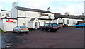
Leaflet Map data © OpenStreetMap
Images are licensed for reuse under creativecommons.org/licenses/by-sa/2.0
Notes
- Clicking on the map will re-center to the selected point.
- The higher the marker number, the further away the image location is from the centre of the postcode.
Image Listing (37 Images Found)
Images are licensed for reuse under creativecommons.org/licenses/by-sa/2.0
Image
Details
Distance
1
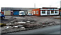
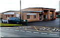
Doodle Wear, Cinderford
The business in the left corner of the brick building is Doodle Wear,
embroidery and vinyl prints, located in Unit 15A, Hollywood Works, Valley Road.
Image: © Jaggery
Taken: 16 Dec 2012
0.02 miles
2
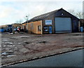
Forest Vehicles Ltd, Cinderford
Car and commercial vehicle repair business located in Valley Road.
Image: © Jaggery
Taken: 16 Dec 2012
0.03 miles
3
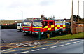
Two Cinderford fire engines
The gleaming red and yellow fire engines are parked in the yard at Cinderford Fire Station. http://www.geograph.org.uk/photo/3262430
Image: © Jaggery
Taken: 16 Dec 2012
0.05 miles
4
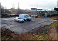
Dangerous buildings - keep out! Cinderford
Viewed from the A4151 Steam Mills Road. The danger notice is on the glass buildings behind the black car.
Image: © Jaggery
Taken: 16 Dec 2012
0.05 miles
5
Cinderford Fire Station
Cinderford Community Fire and Rescue Station, Valley Road, is part of Gloucestershire Fire and Rescue Service. There is no training tower here. The unusual type of tower seen in this view http://www.geograph.org.uk/photo/467483
taken 5 years earlier has gone.
Image: © Jaggery
Taken: 16 Dec 2012
0.06 miles
6
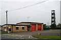
Cinderford Fire Station
Cinderford Fire Station, Valley Road, Cinderford, Gloucestershire
Image: © Kevin Hale
Taken: 10 Jun 2007
0.06 miles
7
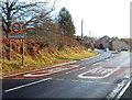
Start of 30mph speed limit at the northern edge of Cinderford
The 40mph speed limit on the A4151 Steam Mills Road reduces to 30mph here.
Ahead, at the Valley Road junction, the A4151 Steam Mills Road becomes the A4151 High Street.
It's unclear whether this sign marks the boundary of Cinderford because several hundred metres
behind the camera there is a more colourful sign http://www.geograph.org.uk/photo/3261860 which could also be the boundary sign.
Image: © Jaggery
Taken: 16 Dec 2012
0.07 miles
8
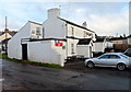
Side view of Upper Bilson Inn, Cinderford
The 40 metre long whitewashed building is on the corner of Valley Road and Seven Stars Road.
http://www.geograph.org.uk/photo/3262456 to a front view.
Image: © Jaggery
Taken: 16 Dec 2012
0.08 miles
9
Upper Bilson Inn, Cinderford
The 40 metre long whitewashed building is on the corner of Valley Road and Seven Stars Road.
http://www.geograph.org.uk/photo/3262457 to a side view.
Image: © Jaggery
Taken: 16 Dec 2012
0.09 miles
10
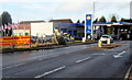
Gulf filling station at the Steam Mills boundary, Cinderford
The boundary sign http://www.geograph.org.uk/photo/3261890 is ahead, a few metres out of shot.
The Gulf filling station used to be a Texaco filling station.
Image: © Jaggery
Taken: 16 Dec 2012
0.09 miles