IMAGES TAKEN NEAR TO
Bilson, CINDERFORD, GL14 2LJ
Introduction
This page details the photographs taken nearby to Bilson, GL14 2LJ by members of the Geograph project.
The Geograph project started in 2005 with the aim of publishing, organising and preserving representative images for every square kilometre of Great Britain, Ireland and the Isle of Man.

There are currently over 7.5m images from over14,400 individuals and you can help contribute to the project by visiting https://www.geograph.org.uk
Image Map (Loading...)


Getting Data...Please wait
Leaflet Map data © OpenStreetMap
Images are licensed for reuse under creativecommons.org/licenses/by-sa/2.0
Notes
- Clicking on the map will re-center to the selected point.
- The higher the marker number, the further away the image location is from the centre of the postcode.
Image Listing (62 Images Found)
Images are licensed for reuse under creativecommons.org/licenses/by-sa/2.0
Image
Details
Distance
1
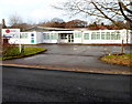
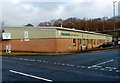
Foxes Bridge Road entrance to GIS Healthcare (Cinderford) factory
This is one of two GIS Healthcare factories in Gloucestershire.
GIS employs 120 people in its factories, most of them disabled. They are responsible for the delivery, collection, refurbishment and servicing of medical equipment for the NHS and the Adult and Community Care Directorate (Social Services) in Gloucestershire.
Image: © Jaggery
Taken: 16 Dec 2012
0.04 miles
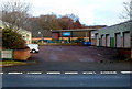
2
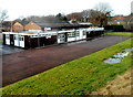
Northern side of GIS Healthcare (Cinderford) factory
Viewed from Valley Road. This is one of two GIS Healthcare factories in Gloucestershire.
GIS employs 120 people in its factories, most of them disabled. They are responsible for the delivery, collection, refurbishment and servicing of medical equipment for the NHS and the Adult and Community Care Directorate (Social Services) in Gloucestershire.
Image: © Jaggery
Taken: 16 Dec 2012
0.05 miles
3
Hollyhill Road in Cinderford
A side road in Forest Vale Industrial Estate, viewed from Forest Vale Road.
Image: © Jaggery
Taken: 16 Dec 2012
0.06 miles
4
Oaklands, Cinderford
Sports bar in Foxes Bridge Road.
Image: © Jaggery
Taken: 16 Dec 2012
0.06 miles
5
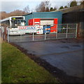
Snax Shack, Cinderford
Closed today, a Sunday, Snax Shack is in a white bus on the north side of Foxes Bridge Road.
A large menu showing the snacks available is displayed on the windscreen. The subtext on the name banner on the gate shows that sandwiches, rolls and burgers are made fresh each day.
Image: © Jaggery
Taken: 16 Dec 2012
0.07 miles
6
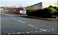
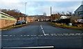
Foxes Bridge Road, Cinderford
Viewed from Forest Vale Road looking towards Valley Road.
Image: © Jaggery
Taken: 16 Dec 2012
0.08 miles
7
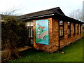
Pictorial representation of Foxes Bridge Centre, Cinderford
Artistic licence has been used here. There is only fox and the proportions are wrong. Adult foxes are usually about 2 feet long, so either the one depicted here is a very large fox, or the bridge is tiny.
Viewed from Valley Road near the Foxes Bridge Road junction.
Image: © Jaggery
Taken: 16 Dec 2012
0.08 miles
8
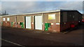
Forest of Dean Age Concern Meal Service premises, Cinderford
Viewed from Foxes Bridge Road.
Image: © Jaggery
Taken: 16 Dec 2012
0.09 miles
9
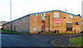
Fordwater, Cinderford
Pumping supplies business in Hollyhill Road, Forest Vale Industrial Estate.
Image: © Jaggery
Taken: 16 Dec 2012
0.10 miles
10
Partington Engineering, Cinderford
Viewed from Forest Vale Road looking towards Partington Engineering in Hollyhill Road.
Image: © Jaggery
Taken: 16 Dec 2012
0.10 miles