IMAGES TAKEN NEAR TO
Station Street, CINDERFORD, GL14 2LG
Introduction
This page details the photographs taken nearby to Station Street, GL14 2LG by members of the Geograph project.
The Geograph project started in 2005 with the aim of publishing, organising and preserving representative images for every square kilometre of Great Britain, Ireland and the Isle of Man.

There are currently over 7.5m images from over14,400 individuals and you can help contribute to the project by visiting https://www.geograph.org.uk
Image Map (Loading...)


Getting Data...Please wait
Leaflet Map data © OpenStreetMap
Images are licensed for reuse under creativecommons.org/licenses/by-sa/2.0
Notes
- Clicking on the map will re-center to the selected point.
- The higher the marker number, the further away the image location is from the centre of the postcode.
Image Listing (51 Images Found)
Images are licensed for reuse under creativecommons.org/licenses/by-sa/2.0
Image
Details
Distance
1
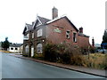
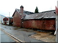
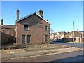
Derelict former Railway Tavern, Cinderford
Viewed across Station Street. It looks bad from this side, but it looks worse from the other side. http://www.geograph.org.uk/photo/3262197
The building was originally a small hotel located opposite Cinderford railway station. The withdrawal of passenger services from the station in 1958 inevitably reduced business here. It had become a pub by the 1970s. The pub closed down in 2007.
Image: © Jaggery
Taken: 16 Dec 2012
0.00 miles
2
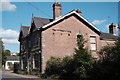
Former Railway Hotel, Cinderford
Once one of the most prestigious pubs in Mitcheldean brewer Francis Wintle's estate, the hotel was directly opposite the town's little-used railway station. The fortunes of the pub inevitably diminished upon the cessation of passenger traffic at the station in 1958, although it soldiered on through the 1970s and 1980s as a Whitbread pub, and the 1990s as a venue called "Trax" (see what they did there?). Punch Taverns renamed the place "The Railway Tavern", but it eventually closed in summer 2007, with a plan in place to redevelop the site as residential apartments. In October 2011 the building "went on fire" in a suspected arson incident, and it remains in post-fire condition today, quietly mouldering away as a reminder of the days when Cinderford was connected, albeit by a thread, to the national rail network. The building was in slightly better condition, retaining its "Railway Tavern" sign, in December 2012, when Jaggery took Image] from the same spot.
Image: © John Winder
Taken: 24 May 2020
0.01 miles
3
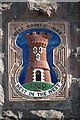
Detail of the derelict Railway Hotel in Cinderford
This plaque still adorns the wall of the former Railway Hotel on Station Street in Cinderford (see Image] for a photo of the building itself, and some history), closed in 2007 and derelict since a suspected arson attack in 2011. The castle motif seen here was used by the Cheltenham Original Brewery, who decorated their own tied houses with similar plaques reading "Cheltenham Ales". After the Second World War, the company acquired the Hereford and the Tredegar breweries and began trading under the banner 'West Country Breweries'; the wording on the plaques was changed to "Cheltenham and Hereford Ales" to reflect this. The "Best in the West" plaques as seen here date from between 1958 and 1967: Whitbread took over West Country Breweries in 1963 but continued to install the plaques for a few years afterwards. These are a surprisingly common sight even now, usually in buildings which are no longer pubs!
Image: © John Winder
Taken: 24 May 2020
0.01 miles
4
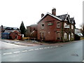
Fire-damaged derelict Railway Tavern, Cinderford
Viewed across Station Street. The building was originally a small hotel located opposite Cinderford railway station. The withdrawal of passenger services from the station in 1958 inevitably reduced business here. It had become a pub by the 1970s. The pub closed down in 2007.
In October 2011 a fire, thought to be arson, caused the damage seen on the left. http://www.geograph.org.uk/photo/3262331
Image: © Jaggery
Taken: 16 Dec 2012
0.02 miles
5
A fire-damaged part of the former Railway Tavern, Cinderford
Arson was suspected when the part of the derelict pub http://www.geograph.org.uk/photo/3262197 was damaged by fire in October 2011.
Image: © Jaggery
Taken: 16 Dec 2012
0.02 miles
6
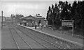
Cinderford station, 1950
View southward towards the buffer-stops of the terminus of the ex-GWR Forest of Dean branch from Newnham via Bullo Pill Junction, closed to passengers 3/11/1958, to goods 1/8/1967; until 8/7/1929 there had also been trains from Drybrook Road on the Severn& Wye Joint line from Lydbrook Junction.
Image: © Walter Dendy, deceased
Taken: 23 Sep 1950
0.03 miles
7
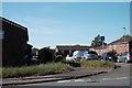
The Keelings, Cinderford
This remarkably dull view of a modern housing estate has very little to commend it, other than that it shows the site of Cinderford's railway station, opened by the Severn & Wye Railway in 1900. The station on this site was actually the town's third station: the S&W had opened two previous stations a fair trek from the town and were eventually forced to extend their line into this site closer to the town centre. The only other point of interest is that Keeling was the family name of two successive chief engineers of the Severn & Wye Company, father and son George William Keeling and George Baker Keeling, the second of whom was responsible for the design of the ill-fated Severn Railway Bridge, and it's nice to see that the name lives on! A roughly equivalent view of the station in its heyday can be seen at http://www.forestprints.co.uk/railway_station_cinderford_v1.htm
Image: © John Winder
Taken: 24 May 2020
0.03 miles
8
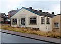
Forest Oaks Amateur Boxing Club gym, Cinderford
Located on the corner of Station Street and Barleycorn Square.
Image: © Jaggery
Taken: 16 Dec 2012
0.03 miles
9
No Progress at the Railway Tavern
Nothing has been done with this derelict pub since this shot from a few years ago. Image
Considering the indecent haste with which some pubs are closed and turned into housing, they're taking their time with this one.
Image: © Des Blenkinsopp
Taken: 9 Feb 2015
0.03 miles
10
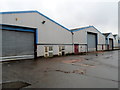
Industrial buildings on the south side of Station Street, Cinderford
The buildings in view are set back about 60 metres from the south side of the street.
Image: © Jaggery
Taken: 16 Dec 2012
0.04 miles