IMAGES TAKEN NEAR TO
Flaxley Street, GL14 2FE
Introduction
This page details the photographs taken nearby to Flaxley Street, GL14 2FE by members of the Geograph project.
The Geograph project started in 2005 with the aim of publishing, organising and preserving representative images for every square kilometre of Great Britain, Ireland and the Isle of Man.

There are currently over 7.5m images from over14,400 individuals and you can help contribute to the project by visiting https://www.geograph.org.uk
Image Map (Loading...)


Getting Data...Please wait
Leaflet Map data © OpenStreetMap
Images are licensed for reuse under creativecommons.org/licenses/by-sa/2.0
Notes
- Clicking on the map will re-center to the selected point.
- The higher the marker number, the further away the image location is from the centre of the postcode.
Image Listing (165 Images Found)
Images are licensed for reuse under creativecommons.org/licenses/by-sa/2.0
Image
Details
Distance
1
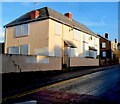
Boarded-up houses in Dockham Road, Cinderford
Two semis and the house behind were sealed up at the December 2012 date of this view.
Image: © Jaggery
Taken: 16 Dec 2012
0.05 miles
2
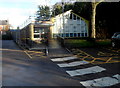
Cinderford Library
A white crossing painted on the road surface leads to the entrance of the Belle Vue Road library,
part of Gloucestershire County Council's library service.
Image: © Jaggery
Taken: 16 Dec 2012
0.06 miles
3
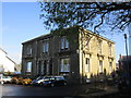
The Register Office, Cinderford
The former Police Station.
Image: © Jonathan Thacker
Taken: 10 Oct 2014
0.07 miles
4
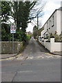
St Annals Road, Cinderford
A tight squeeze - links Belle Vue Road with Dockham Road.
Image: © Pauline E
Taken: 17 Mar 2008
0.07 miles
5
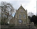
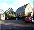
St. Stephen's Church, Belle Vue Road, Cinderford
Consecrated in 1890 and built in an early 14th century style. The church was designed by Lingen Barker.
Image: © Pauline E
Taken: 17 Mar 2008
0.07 miles
6
The Library, Cinderford
In Belle Vue Road.
Image: © Pauline E
Taken: 17 Mar 2008
0.07 miles
7
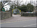
Entrance to Belle Vue Centre, Cinderford
Viewed across Belle Vue Road. Belle Vue Centre houses the Cinderford branch of Gloucestershire County Council's Registration Service, for the registration of births, deaths and marriages.
Various civil ceremonies can be held here, including marriage and civil partnership.
Image: © Jaggery
Taken: 16 Dec 2012
0.07 miles
8
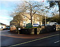
The Beavis Memorial Ground, Cinderford
Viewed from the Dockham Road side. This is the home ground of Cinderford Rugby Football Club.
Image: © Jaggery
Taken: 16 Dec 2012
0.09 miles
9
Grade II listed Cinderford Methodist Church viewed from the west
Viewed from Belle Vue Road. The church is in the Gloucestershire Methodist Circuit, part of the Bristol District of The Methodist Church. The church was built in 1849, renovated in 1881. Grade II listing was awarded in July 1985.
Image: © Jaggery
Taken: 16 Dec 2012
0.09 miles
10
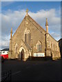
Grade II listed Cinderford Methodist Church viewed from the south
Viewed from Belle Vue Road. The church is in the Gloucestershire Methodist Circuit,
part of the Bristol District of The Methodist Church.
The church was built in 1849, renovated in 1881.
Grade II listing was awarded in July 1985.
Image: © Jaggery
Taken: 16 Dec 2012
0.09 miles