IMAGES TAKEN NEAR TO
Victoria Street, CINDERFORD, GL14 2ET
Introduction
This page details the photographs taken nearby to Victoria Street, GL14 2ET by members of the Geograph project.
The Geograph project started in 2005 with the aim of publishing, organising and preserving representative images for every square kilometre of Great Britain, Ireland and the Isle of Man.

There are currently over 7.5m images from over14,400 individuals and you can help contribute to the project by visiting https://www.geograph.org.uk
Image Map (Loading...)


Getting Data...Please wait
Leaflet Map data © OpenStreetMap
Images are licensed for reuse under creativecommons.org/licenses/by-sa/2.0
Notes
- Clicking on the map will re-center to the selected point.
- The higher the marker number, the further away the image location is from the centre of the postcode.
Image Listing (170 Images Found)
Images are licensed for reuse under creativecommons.org/licenses/by-sa/2.0
Image
Details
Distance
1
Soldiers & Sailors Club, Commercial Street, Cinderford
A distinctive building at the apex of Commercial Street and Victoria Street.
Image: © Pauline E
Taken: 17 Mar 2008
0.02 miles
2
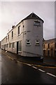
Soldiers and Sailors Club, Cinderford, Forest of Dean
This tall, narrow building is crammed into the thin wedge of land as Victoria Street joins Commercial Street. The Soldiers and Sailors Club has been a landmark in Cinderford for many decades.
Image: © Eric Soons
Taken: 10 Nov 2008
0.03 miles
3
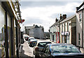
Corner of Victoria Street and Commercial Street, Cinderford
This view was taken from the point where Market Street behind the camera splits into Victoria Street (on the right) and Commercial Street. The building on the corner is the Soldiers and Sailors Club. http://www.geograph.org.uk/photo/3265938
Image: © Jaggery
Taken: 16 Dec 2012
0.03 miles
4
Woodside House flats, Cinderford
Viewed across Commercial Street from opposite Lamb Lane.
Image: © Jaggery
Taken: 16 Dec 2012
0.03 miles
5
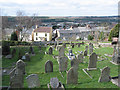
View across the cemetery
From Commercial Street, across the cemetery next to the Baptist Chapel, there is a wide view towards the forest. The houses are in Victoria Street.
Image: © Pauline E
Taken: 17 Mar 2008
0.03 miles
6
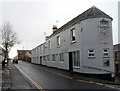
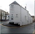
Soldiers and Sailors Club, Cinderford
The only identification on this Commercial Street building is a small name plate on the wall at the entrance. The name on the side wall seen here http://www.geograph.org.uk/photo/1040219 has gone.
Image: © Jaggery
Taken: 16 Dec 2012
0.04 miles
7
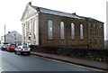
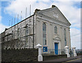
North side of Grade II listed Cinderford Baptist Church
Viewed across Commercial Street. A tablet on the front of the building records its opening for worship in 1860 as Cinderford Baptist Chapel. The five-storey Sunday School on the right was added soon afterwards. Grade II listed in July 1985. http://www.geograph.org.uk/photo/3265995 to another view which includes the churchyard.
Image: © Jaggery
Taken: 16 Dec 2012
0.04 miles
8
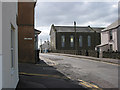
Approaching the Baptist Chapel
Lamb Lane junction with Commercial Street.
Image: © Pauline E
Taken: 17 Mar 2008
0.04 miles
9
Baptist Chapel, Commercial Street, Cinderford
The chapel was built in 1860 by the Bible Christian Chapel for the workmen's community. Currently undergoing some repairs.
Image: © Pauline E
Taken: 17 Mar 2008
0.05 miles
10
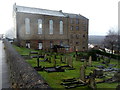
Grade II listed Cinderford Baptist Church and churchyard
Cinderford is only a small town, so I was unprepared for the sheer size of this church located on the west side of Commercial Street. A tablet on the front of the building records its opening for worship in 1860 as Cinderford Baptist Chapel. The five-storey Sunday School on the right was added soon afterwards.
Grade II listed in July 1985.
Image: © Jaggery
Taken: 16 Dec 2012
0.05 miles