IMAGES TAKEN NEAR TO
Causeway Road, CINDERFORD, GL14 2BU
Introduction
This page details the photographs taken nearby to Causeway Road, GL14 2BU by members of the Geograph project.
The Geograph project started in 2005 with the aim of publishing, organising and preserving representative images for every square kilometre of Great Britain, Ireland and the Isle of Man.

There are currently over 7.5m images from over14,400 individuals and you can help contribute to the project by visiting https://www.geograph.org.uk
Image Map (Loading...)


Getting Data...Please wait
Leaflet Map data © OpenStreetMap
Images are licensed for reuse under creativecommons.org/licenses/by-sa/2.0
Notes
- Clicking on the map will re-center to the selected point.
- The higher the marker number, the further away the image location is from the centre of the postcode.
Image Listing (31 Images Found)
Images are licensed for reuse under creativecommons.org/licenses/by-sa/2.0
Image
Details
Distance
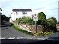
1
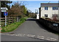
Northern end of Littledean Hill Road
Viewed across Causeway Road. The blue, white and red sign shows that this is not a through route.
Image: © Jaggery
Taken: 12 Apr 2015
0.05 miles
2
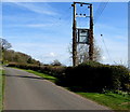
Rural electricity substation, Cinderford
Alongside Littledean Hill Road north of Causeway Road. The substation is in the background here. http://www.geograph.org.uk/photo/4430054
Image: © Jaggery
Taken: 12 Apr 2015
0.05 miles
3
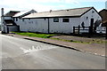
North side of Little Pebbles Childcare, Cinderford
Causeway Road side of the premises on the corner of Littledean Hill Road, previously the Royal Foresters pub.
Image: © Jaggery
Taken: 12 Apr 2015
0.06 miles
4
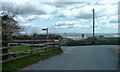
Littledean Hill Road
At junction with Causeway Road. Road to left leads to Collafield and Edgehills. River Severn visible in background.
Image: © Clint Mann
Taken: 23 Apr 2016
0.06 miles
5
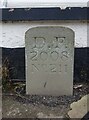
Boundary Stone, Cinderford
On the corner of Littledean Hill Road, and the chamfered corner of the former Royal Forrester pub. Technically on private land but effectively just off the road.
The context view of the ex pub is Image
Inscription: D.F / 2008 / Nᴼ. 211
Milestone Society National ID: GL_DFCINLIT211em
Image: © Mr Red
Taken: 17 Nov 2022
0.07 miles
6
Littledean Hill Road meets The Ruffitt
Image: © Alex McGregor
Taken: 1 Sep 2013
0.07 miles
7
Forest Rise, Cinderford
Cul-de-sac on the south side of Causeway Road.
Image: © Jaggery
Taken: 12 Apr 2015
0.07 miles
8
Former Royal Forester, Cinderford
The large building on the corner of Causeway Road and Littledean Hill Road is now Little Pebbles Childcare.
The name on a half-moon shaped pane of glass shows The Royal Forester, the previous occupier.
Image: © Jaggery
Taken: 12 Apr 2015
0.07 miles
9
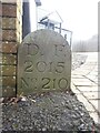
Boundary Stone, Littledean Hill
On the Southern side of the road (the Ruffitt) in the driveway of "Stone Cottage".
Inscription: D.F / 2015 / Nᴼ. 210
Milestone Society National ID: GL_DFCINLIT210em
Image: © Mr Red
Taken: 18 Nov 2022
0.07 miles
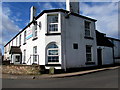
10
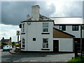
The Royal Foresters, Littledean Hill
The pub has fine views to the east.
Set on the corner of Littledean Hill Road and Causeway Road.
Image: © Jonathan Billinger
Taken: 25 Aug 2009
0.08 miles