IMAGES TAKEN NEAR TO
Littledean Hill Road, CINDERFORD, GL14 2BJ
Introduction
This page details the photographs taken nearby to Littledean Hill Road, GL14 2BJ by members of the Geograph project.
The Geograph project started in 2005 with the aim of publishing, organising and preserving representative images for every square kilometre of Great Britain, Ireland and the Isle of Man.

There are currently over 7.5m images from over14,400 individuals and you can help contribute to the project by visiting https://www.geograph.org.uk
Image Map (Loading...)


Getting Data...Please wait
Leaflet Map data © OpenStreetMap
Images are licensed for reuse under creativecommons.org/licenses/by-sa/2.0
Notes
- Clicking on the map will re-center to the selected point.
- The higher the marker number, the further away the image location is from the centre of the postcode.
Image Listing (40 Images Found)
Images are licensed for reuse under creativecommons.org/licenses/by-sa/2.0
Image
Details
Distance
1
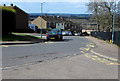
The Oak Field, Cinderford
Cul-de-sac on the west side of Littledean Hill Road.
Image: © Jaggery
Taken: 12 Apr 2015
0.04 miles
2
Severn View, Cinderford
Cul-de-sac on the south side of Latimer Road.
Image: © Jaggery
Taken: 12 Apr 2015
0.05 miles
3
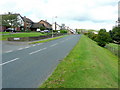
Littledean Hill Road
Looking north by The Oak Field. The spectacular view to the right is Image
Image: © Jonathan Billinger
Taken: 25 Aug 2009
0.07 miles
4
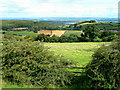
View to Gloucester and the Cotswolds
Looking east from Littledean Hill Road, the bend of the Severn at Westbury can clearly be seen.
Image: © Jonathan Billinger
Taken: 25 Aug 2009
0.07 miles
5
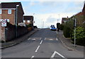
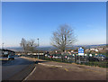
Latimer Road, Cinderford
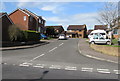
Viewed from Littledean Hill Road. The 20mph speed limit and speed bumps
are on the approach to Forest View Primary School gates. http://www.geograph.org.uk/photo/4429092
Image: © Jaggery
Taken: 12 Apr 2015
0.07 miles
6
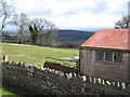
Outbuilding on Littledean Hill Road
Occupants of the houses which border this road, east of Cinderford, have stunning views over the vale of Gloucester, but one or two have ugly outbuildings spoiling the scene. The wooded hill in the distance is Chestnuts Hill.
Image: © Pauline E
Taken: 27 Mar 2008
0.07 miles
7
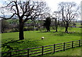
Sheep and lambs in a field at the eastern edge of Cinderford
Viewed across Littledean Hill Road in mid April 2015.
Image: © Jaggery
Taken: 12 Apr 2015
0.07 miles
8
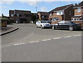
Latimer Road west of Forest View Primary School, Cinderford
The yellow road markings are near the school gates. http://www.geograph.org.uk/photo/4429092
Image: © Jaggery
Taken: 12 Apr 2015
0.09 miles
9
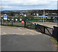
Primary school gates, Cinderford
At the southern (Latimer Road) edge of Forest View Primary School. http://www.geograph.org.uk/photo/4429086
Image: © Jaggery
Taken: 12 Apr 2015
0.09 miles
10
Outside Forest View School
You can see where they got the name from.
This is to the west of Littledean Hill Road, which has spectacular views eastwards out over the Severn Estuary from its route along the top of a ridge.
The views in this direction are not so obvious because that's where most of the housing is.
Image: © Des Blenkinsopp
Taken: 9 Feb 2015
0.10 miles